Fun weekend, swell Mon/Tues but with average winds
Victoria Forecast by Craig Brokensha (issued Friday 14th August)
Best Days: Saturday, Sunday Surf Coast, Monday morning Surf Coast, both coasts later Tuesday, Wednesday onwards east of Melbourne
Recap
Average morning of surf yesterday with the new W/SW groundswell not fully in yet and an early onshore change creating less than desirable conditions. Later in the day the swell became stronger as a new SW pulse filled in and conditions improved on the Surf Coast with lighter W'ly winds.
This morning the mix of good SW and W/SW groundswell were offering clean 3-4ft sets on the Surf Coast with bumpy 6ft waves on the Mornington Peninsula. Winds will swing more W'ly through the afternoon as the swell eases, so make the most of this morning.
This weekend and next week (Aug 14 - 21)
There's been no real change to the weekends forecast, besides tomorrow morning probably being more in the 2-3ft range across the Surf Coast and 4-6ft on the Mornington Peninsula. Into the mid-late afternoon a good new SW groundswell should build, reaching the 4ft range on the Surf Coast and 6ft to possibly 8ft on the Mornington Peninsula under variable winds.
As the swell eases from 3-4ft on the Surf Coast and 6ft+ on the Mornington Peninsula Sunday, NW tending W/NW breezes will favour locations west of Melbourne.
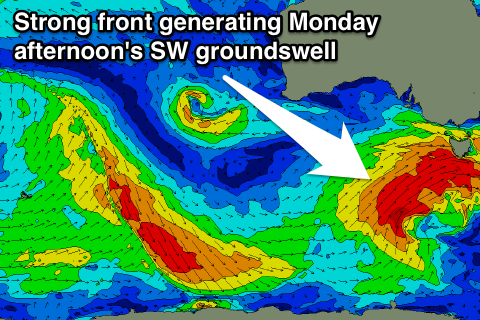
 Monday's building SW groundswell is still on track, with an upgrade in size but so are the onshore winds into the afternoon as it really kicks. The morning will be fun on the Surf Coast with a W/NW'ly and 3-4ft of swell but the afternoon will see SW breezes as the swell builds towards the 5-6ft range.
Tuesday should see this swell, generated by a strengthening polar low pushing up towards us, easing from 4-5ft on the Surf Coast and 6-8ft on the Mornington Peninsula from a more S/SW direction with lingering S/SW tending S/SE winds (possibly variable late afternoon). There's a slim chance for an early W'ly around Torquay, but we'll review this Monday.
Wednesday will be better east of Melbourne as the surf continues to ease under NE breezes.
A small pulse of S/SW groundswell is due Thursday afternoon from strong but fetch limited polar frontal activity early next week, and N/NE winds will favour the Mornington Peninsula. We should see inconsistent 2ft+ sets on the Surf Coast and 3-4ft+ waves on the Mornington Peninsula before fading Friday.
Longer term there's nothing significant on the cards as a blocking cut-off low meanders through the Bight, so make the most of the coming waves over the weekend!


Comments
Are you still forecasting S/SW winds early in Torquay as per the graphs or should daybreak bring W/NW offshore winds? Thanks
Are you talking about tomorrow?
Forecast graph has a 2kt SSW, so as said light and variable, but should tend locally offshore from the NW.
Yep I was, thanks for the reply :)