Exposed breaks, then more swell on the weekend, better early next week
Victoria Forecast by Craig Brokensha (issued Wednesday 3rd June)
Best Days: Thursday exposed breaks, Friday morning Mornington Peninsula for small clean waves, Saturday and Sunday both coasts for an inconsistent swell, Monday and early Tuesday Surf Coast
Recap
A period of lighter winds around Torquay yesterday morning and workable 3-4ft sets before a weak onshore developed into the afternoon. The Mornington Peninsula remained onshore and poor with plenty of size.
Today lighter winds have again created cleaner conditions across both coasts with smaller 2-3ft sets on the Surf Coast and 3-5ft waves on the Mornington Peninsula.
This week and weekend (Jun 2 – Jun 7)
Tomorrow will be much cleaner and straighter across both coasts with local offshore winds, but the swell small with inconsistent 2ft sets west of Melbourne and 3ft to occasionally 4ft on the Mornington Peninsula through the morning, smaller into the afternoon.
Come Friday the surf is due to be tiny and with early light offshore winds across both coasts ahead of a weak W'ly breeze into the afternoon. Therefore the Mornington Peninsula will be the only option Friday morning.
A late increase in long-range and inconsistent W/SW groundswell is likely across both coasts, peaking through Saturday.
This swell was generated in our far western swell window in the south-eastern Indian Ocean and is only due to offer very infrequent 2ft+ wave on the Surf Coast and 4-5ft sets on the Mornington Peninsula.
A slight stronger and more consistent pulse of SW swell is due into the afternoon, offering the odd 3ft set on the Surf Coast and 6ft sets on the Mornington Peninsula. This will be a mix of small SW swell generated by an intense but small and unfavourably tracking low south-east and perpendicular to our swell window during Thursday/Friday and some new long-range W/SW groundswell energy.
Both swells should ease back into Sunday morning with infrequent 2-3ft sets on the Surf Coast and 4-6ft waves on the Mornington Peninsula. Winds will be good for both coasts all weekend, with a persistent N/NW-NW wind on the Surf Coast, and straighter N'ly breezes on the Mornington Peninsula.
 Next week onwards (Jun 8 onwards)
Our better pulse of W/SW groundswell due later Sunday has now been pushed back to Monday, with it due to be followed up by a larger swell through Tuesday and Wednesday.
This is linked to a strong node of the Long Wave Trough moving in from the west, bringing the frontal activity in the south-eastern Indian Ocean, under the country and then across Tassie into the start of next week.
Initially a strong but patchy frontal system moving in through Saturday and Sunday should produce a moderate sized W/SW groundswell building through Monday from 3ft+ through the morning on the Surf Coast and 6ft+ on the Mornington Peninsula, to 3-5ft and 8ft respectively through the afternoon.
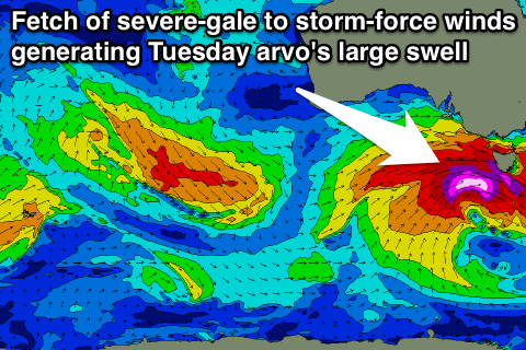
The strongest of all the frontal systems pushing through on Monday afternoon and evening, should aim a fetch of severe-gale to storm-force W/SW tending SW winds through our swell window, producing a large W/SW groundswell for Tuesday afternoon, easing out of the SW Wednesday morning.
The Surf Coast should build to 6ft+ through the day with 8ft bombs at swell magnets and 10-12ft waves on the Mornington Peninsula. A drop in size is then expected from 4-6ft and 8ft respectively Wednesday morning.
Winds should be offshore all Monday from the NW, but come Tuesday an early W/NW breeze will give into a SW change before the swells starts to kick. Wednesday should see an early W'ly around Torquay but the swell will be far from lined up, while other locations are due to see lighter and possibly variable S'ly winds. More on this Friday though.

