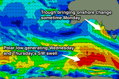
Fun swells with windows of good conditions
Victoria Forecast by Craig Brokensha (issued Friday 3rd April)
Best Days: Beaches mid-late morning tomorrow, Surf Coast Sunday, Surf Coast Monday morning, Torquay early Wednesday, Surf Coast Thursday morning
Recap
Yesterday started small and weak with a fresh to strong onshore change and developing windswell. Wave heights increased threefold through the day though, kicking to a stormy 4-6ft on the Surf Coast and a bigger 6ft+ on the Mornington Peninsula but with no real decent options for a wave.
With the passing of the deepening trough overnight, we're left with an easing and weak 2-3ft of windswell across the Surf Coast and 4-5ft on the Mornington Peninsula with a persistent onshore wind.
 This weekend and next week (Apr 4 - 10)
We've got a fun period ahead with plenty of swell and a general improvement in winds across the state.
Our inconsistent increase in SW groundswell due tomorrow is still on track with the Surf Coast due to build to 2-3ft through the day with 4-6ft sets on the Mornington Peninsula.
Winds are looking better with improving conditions through the morning as fresh E/SE breezes at dawn, ease and swing more E/NE (even possibly NE) through the morning. SE sea breezes will then redevelop into the afternoon. So a mid-late morning surf on the beaches across both coasts will be best.
A better pulse of inconsistent SW groundswell due Sunday should offer 3ft+ waves across the Surf Coast with 5-6ft+ sets on the Mornington Peninsula (from midday onwards).
Winds will be tricky and best for the Surf Coast with a NW tending W/NW breeze through the morning ahead of a mid-afternoon and shallow SW change. The Mornington Peninsula is looking average with dawn the only chance for a very brief N'ly.
Monday morning should see Sunday's swell start to drop away, but inconsistent 3ft waves should continue on the Surf Coast and 5-6ft sets on the Mornington Peninsula under offshore NW winds west of Melbourne. The Mornington Peninsula will continue to be average with a morning W/NW'ly.
At some stage a strong onshore S/SW change is due as another surface trough pushes in from the west, but the models are divergent on the timing of this still. One has it through on dawn, while latest GFS updates don't have to through until the late afternoon/evening. Best bet though is to get a morning surf in just in case it comes in earlier than expected.
Into Tuesday, Wednesday afternoon and Thursday morning a couple of stronger pulses of SW groundswell are due across the state.
The first for Tuesday will be generated this evening and tomorrow by a strong but weakening polar front pushing up towards us from south-west of WA. This swell should come in at a better 3-4ft across the Surf Coast with 5-6ft+ sets on the Mornington Peninsula.
Wednesday morning should start out around a similar size, but a stronger SW groundswell is due into the afternoon, produced by a vigorous polar low developing south-west of us through Sunday evening.
An initial fetch of pre-frontal W/NW gales will then be immediately followed by a better fetch of SW gales, generating a strong SW groundswell, building to 3-5ft Wednesday afternoon and then easing from a similar size range Thursday morning.
Now, conditions are looking average Tuesday as Monday's change lingers with a fresh to strong S/SW tending SW breeze due. There'll also be moderate amounts of S/SW windswell in the mix from the change to 3-4ft across the Surf Coast and 6ft+ on the Mornington Peninsula.
Wednesday will be poor across most locations with a fresh SW'ly, but the Torquay region should see W/NW winds through the morning. Thursday looks really fun on the Surf Coast with a morning W/NW breeze and SW onshores into the afternoon.
One final pulse of S/SW groundswell is on the cards for Friday but winds look to go SE as a small high pressure ridge moves in from the west. We'll have a closer look at this on Monday though. Have a happy and safe Easter!


Comments
Hey craig do you think westernport will have any good surf next week, if there is what spots there
Thanks heaps
Lachie you need to start doing a bit of research for yourself mate. Just read the forecast and then go figure it out by yourself. Sometimes you'll score, other times not..
You can't expect anyone to name each wave that might be ok.
Don't listen to them Lachie .
Long Island point and French island should be smoking all week .
Thanks man! I am from shepparton and just wanted to know if there is any good surf thats better then gunna
Where abouts is long island point and french island located thanks heaps
I can only take you so far mate ..... You'll need to look up maps .
Around Seapray, Isn't it?
Give or take a few K's