Great period ahead for the Surf Coast
Victoria Forecast by Craig Brokensha (issued Friday 6th March)
Best Days: Every day on the Surf Coast, east of Melbourne Monday and Tuesday mornings, possibly dawn Wednesday
Recap
A large pulse of SW groundswell filled in yesterday to the easy 6ft range with bigger sets across the Surf Coast and 10ft+ stormy surf on the Mornington Peninsula. Conditions were terrible though with a strong onshore wind.
Today the swell has dropped back a touch but still remained in the solid 4-5ft range with larger 6ft sets at swell magnets on the Surf Coast and a still large 8ft on the Mornington Peninsula.
Conditions improved with lighter W/NW winds developing across the Surf Coast but the swell was still fairly unruly, while the Mornington Peninsula was a no go.

This weekend (Mar 7 - 8)
The weekend ahead is looking great for the Surf Coast with smaller amounts of swell but great winds for the most part.
Today's reinforcing SW swell is expected to drop back from 3-4ft tomorrow morning across the Surf Coast and 6ft to occasionally 8ft on the Mornington Peninsula as winds swing NW around Torquay and more W/NW east of Melbourne. Winds now look to hold from the W into the afternoon, favouring the protected reefs all day west of Melbourne.
Sunday should see smaller 2-3ft waves with the odd bigger set at swell magnets, with a possible late kick in new SW groundswell late in the day.
Winds should be great again and from the NW before tending variable early afternoon and then W/SW later in the day.
Next week onwards (Mar 9 onwards)
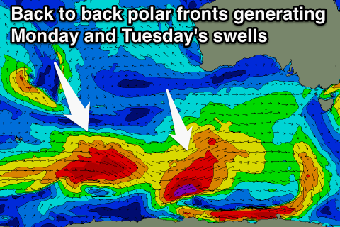
Sunday's possible late increase in SW groundswell should be visible Monday morning, generated by a strong but short-lived polar low firing up to our south-west today before weakening into tomorrow and tracking across Tassie into the evening.
Only 3ft of swell is now due off this front Monday morning on the Surf Coast with 6ft sets on the Mornington Peninsula under morning offshore N/NW winds, but a gusty SW change is due around midday/early afternoon.
A secondary larger increase in SW swell is due through Tuesday though, produced by a secondary stronger and longer lived polar front firing up closely after the initial system.
The Surf Coast is looking at bigger 3-4ft+ sets with 6-8ft waves on the Mornington Peninsula.
Winds are now looking better than they were on Wednesday, with Monday's change being quite shallow resulting in variable breezes developing through Tuesday morning. Afternoon SE sea breezes will create average conditions into the afternoon though.
From Wednesday moderate amounts of reinforcing SW swell are due through Thursday and Friday from weaker frontal activity under the country during the middle of next week, but the size will be a touch smaller than Tuesday's pulse.
Winds are due to kick back to the NW through the morning Wednesday (possible N'ly early east of Melbourne, while Thursday will be best around Torquay with an early offshore ahead of a SW change. We'll have a closer look at this on Monday though. Have a great weekend!

