Improving Thursday, pumping Friday, onshore from Sunday arvo
Victoria Forecast by Craig Brokensha (issued Wednesday 6th August)
Best Days: Possibly Thursday morning on the Surf Coast, but more so the afternoon, Friday, Saturday
Recap
Two pulses of strong W/SW groundswell filled in yesterday. The first came in at the 3-5ft range across the Surf Coast yesterday morning with 6-8ft sets on the Mornington Peninsula under fresh NW winds.
A stronger W/SW groundswell pulsed into the afternoon with 6ft sets developing at swell magnets on the Surf Coast and larger waves to the east as winds tending more W'ly.
This swell is easing back through this morning but there were still plenty of waves in the 4-5ft+ range on the Surf Coast with messy 8ft bombs to the east under light to moderate NW winds.We should see wind strengthen from the W/NW through the day though as the swell continues to ease.
This week and weekend (Aug 7 - 10)
We may see a late increase in new W/SW swell this evening but tomorrow morning will reveal the most size.
The source of this swell is an unfavourable fetch of strengthening W/NW gales to our south-west, with moderate levels of W/SW side-band energy expected to spread out and up into us.
The Surf Coast should see 3-5ft waves early before easing during the day with 6-8ft sets on the Mornington Peninsula.
Winds are still looking funky tomorrow as the front moves through bringing early fresh but rapidly easing SW winds to most regions. In fact winds should tend variable into the afternoon creating improving conditions. The Surf Coast is tricky but we are likely to see early W/NW winds around Torquay and these should ease and become variable through the day. So if conditions are poor early on the Surf Coast, try for a surf midday onwards when things will improve.
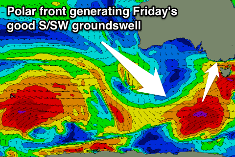
 Friday looks great as a new S/SW groundswell peaks through the morning. This is being generated by a vigorous polar front firing up late in our swell window to the south-west of Tassie. This is producing a fetch of severe-gale SW winds, with a strong S/SW groundswell due to fill in Friday from it.
The Surf Coast should offer 3-4ft waves most of the day with the possibility of the odd bigger bomb, while the Mornington Peninsula should see 6ft+ sets. Winds will be excellent and moderate to fresh but easing from the NW all day (N/NW at times on the Mornington Peninsula).
Friday's swell will drop steadily into Saturday from 2-3ft and 3-5ft respectively as winds remain favourable from the N/NW during the morning and NW into then afternoon. The Mornington Peninsula may see a straighter N'ly early creating fun surf.
Sunday morning will start off slow but the strong increase in large SW groundswell is still on the cards for the afternoon, and so are the onshore winds.
This swell will be produced by a phenomenal polar frontal progression that formed Monday west of Heard Island and is now pushing through the Southern Indian Ocean while generating a broad fetch of severe-gale W/SW winds. This system will continue tracking east and under the country while weakening a touch but continuing to produce gale-force winds aimed towards us.
A large and powerful SW groundswell will result, building later Sunday, peaking overnight but holding well Monday morning.
The Surf Coast should see 5-6ft+ sets developing later in the day with similar size surf into Monday morning and larger 8-10ft waves on the Mornington Peninsula. Unfortunately early W/NW winds on Sunday morning will swing fresh S/SW through the day with poor S/SE winds into Monday.
Tuesday will remain average with S/SE winds as a slow moving high pushes in from the west. More on this in Friday's update though.

