Average weekend, great from Monday
Victoria Forecast by Craig Brokensha (issued Friday 18th July)
Best Days: Sunday morning for keen surfers around Torquay, Monday, Tuesday, Wednesday
Recap
A new inconsistent W/SW groundswell came in at 2-3ft across the Surf Coast yesterday morning with larger 6ft sets on the Mornington Peninsula but a stronger afternoon increase in size to 3-5ft and 6-8ft+ respectively unfortunately didn't really eventuate. Instead the 13th Beach saw choppy 3-4ft sets as winds strengthened from the W/NW while the Mornington Peninsula pulsed towards 8ft.
Overnight a strong change moved through and as expected everywhere is poor with fresh onshore winds but with larger surf associated with a new mix of W/SW groundswell and short-range SW swell.
This weekend (Jul 19 - 20)
Today's mix of swells will ease through tomorrow but winds will unfortunately linger onshore across most of the state from the S/SW. Torquay is also likely to play out similar to today, with only a slight chance of an early W'ly, but less so than normal due to the overarching southerly pressure gradient across the state. The main thing is that it won't be worth a drive from Melbourne again.
Sunday morning will be the pick of the weekend as winds ease enough to allow for an early W/NW breeze around Torquay but conditions will be quite lumpy and wobbly with an inconsistent 2-3ft of swell. Light onshores to the east will continue to create average conditions.
This Monday onwards (Jul 21 onwards)
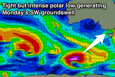
Next week is looking a lot better for surf with Monday's fun pulse of SW groundswell still on track under favourable winds.
 This swell is forecast to be produced by a tight but strong polar low firing up well south of WA this morning, aiming a fetch of severe-gale to storm-force W/SW winds through our south-western swell window.
This should provide good but inconsistent 3-4ft sets across the Surf Coast Monday morning with larger 6ft to possibly 8ft sets on the Mornington Peninsula. Conditions will be great across both coasts with local offshore winds ahead of a shift to to a light NE'ly into the afternoon, favouring locations east of Melbourne and the Surf Coast beaches.
A drop in size is due into the afternoon and down further into Tuesday from 2-3ft and 4-6ft respectively as winds again play out favourably for both coasts.
Wednesday's secondary pulse of small SW groundswell doesn't look to be anything major with it only expected to keep inconsistent 2ft waves hitting the Surf Coast and 3-5ft sets on the Mornington Peninsula under stronger N'ly winds.
Longer term the models diverge on a frontal progression pushing through the Bight during the middle to end of next week. GFS and ACCESS have a vigorous progression with a moderate to large sized W/SW groundswell for late in the week, whereas ECMWF has a much weaker and subdued system with no considerable swell at all.
Gut feel has me leaning towards GFS and ACCESS but we'll review this Monday.

