Plenty of NE swell, but tricky winds

Sydney, Hunter and Illawarra Surf Forecast by Ben Matson (issued Wednesday 17th October)
Best Days: Fri AM: period of light winds and peaky E/NE thru' NE swell. There'll be plenty of waves over the weekend too but winds are dicey. Same for next week: plenty of swell potential but conditions are unsure.
Recap: Strong NE swell pushed a solid 6ft+ at exposed NE facing beaches on Tuesday, before easing back to around 4ft today. Winds have however been moderate to fresh from the NE so conditions haven’t been great.
This week (Oct 18 - 19)
Today’s Forecaster Notes are brought to you by Rip Curl
No major changes to the short term forecast. Fresh N/NE winds are expected through Thursday, creating poor conditions away from sheltered northern corners, which will be much smaller than exposed beaches due to the prevailing NE swell direction. Winds should be a little lighter early morning but it's unlikely we'll see anything fantastic in the surf department.
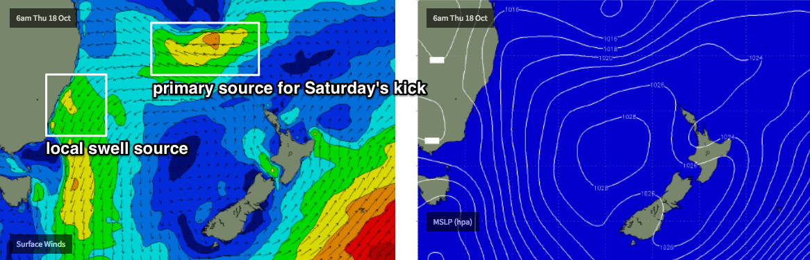
Wave heights are expected to level out in the 3-4ft+ range both days, being a mix of local NE windswell and better quality E/NE mid-range swell from a stationary trough in the northern Tasman Sea.
Friday morning is still likely to see a brief weakening of the ridge through the Tasman Sea, which should bring about a period of light winds through the morning, however freshening NE winds are expected into the afternoon as the ridge regains some strength.
The morning's period of light winds probably won’t be enough to completely clean up conditions but it’s likely to offer some of the smoother waves seen this week.
Water temps are reportedly down 1-2 degrees since the start of the week, and I wouldn’t be surprised if it drops a little more as we head towards the weekend. So you may need to being back the winter rubber!
This weekend (Oct 20 - 21)
The trough in the northern Tasman Sea is expected to restrengthen through Thursday (see below), generating new E/NE swells that will rebuild surf size back into the 4-5ft range into Saturday, before easing into Sunday.
Note: this size range is a little higher than the models are estimating (and is only for reliable NE facing swell magnets), however I’m utilising the assumption of a stationary fetch working on a pre-existing active sea state within good striking range from the coast, that’s likely to punch much higher than our computer generated forecast of around 3ft.
There’ll also be some local NE windswell in the mix too, around 3ft.
Saturday’s surface conditions look tricky, with the models delaying the arrival of a shallow southerly change since Monday's notes were written - it’s now expected to push into the South Coast during the afternoon, which means local conditions (across Sydney, Hunter and Illawarra coasts) may be spoiled by freshening NE winds on Saturday.
At this stage it’s also hard to have confidence in Sunday’s surf conditions. The US atmospheric model (underpinning our wave model) is forecasting a small closed low to form off the South Coast, though with only a very small fetch so low swell potential at this stage. But, winds would be southerly in most districts if this occured.
On the other hand, other models expect Saturday’s southerly change to stall just south of the Illawarra, leaving locations north from Wollongong under a variable tending NE airstream, and confining moderate S'ly winds to the South Coast. This is the most likely option for my money.
Either way there won’t be any shortage of swell both days, but we just need a little more clarity on the track and position of this meandering coastal trough to firm up the weekend’s surf prospects. More on this in Friday’s update.
Next week (Oct 22 onwards)
There's still lots of divergence between models runs for next week, but it’s very unlikely that we’ll see a period of small surf conditions settle in.
The trades are expected remain active south of Fiji and chances are pretty good that a broad trough will linger from the lower Coral Sea through the western Tasman Sea along the NSW Coast, with a resulting E/NE infeed supplying plenty of swell. And there’s still a chance that we’ll see a more significant feature develop within our immediate swell window too.
See you Friday!
Comments
Severe storms inbound with Penrith just seeing 49.6mm in half an hour, and 69.6mm in the last hour.