Extended period of mediocrity across Southern NSW
Sydney, Hunter and Illawarra Surf Forecast by Ben Matson (issued Monday 23rd October)
Best Days: No great days in general due to low swells and average winds.
Recap: The weekend was a little average. Saturday delivered fresh southerly winds at most coasts as Friday’s southerly swell eased. A few locations (such as the Northern Beaches) saw an improvement in conditions with winds slowly swinging around to the W/SW, but in general it wasn’t anything to get excited about. Sunday saw much smaller, weaker surf with lighter winds. A new S’ly groundswell built overnight and has provided some OK waves about south facing beaches and up into the Hunter today, though it’s come in a fraction smaller and much less consistent than previously estimated. Conditions were briefly clean at dawn with light offshore winds, but this gave way to moderate to fresh southerlies from about 8am, which are now easing.
This week (Oct 24 - Oct 27)
Let’s be straight upfront - the entire forecast period looks very ordinary.
Today’s south swell will ease slowly through Tuesday, offering occasional 2ft sets at reliable south swell magnets in the morning and a few bigger waves up across the Hunter. But most Sydney beaches will remain very small, and winds will freshen from the northern quadrant all day. So, aim for the early morning if you’re desperate, when we may see a brief period of NW winds.
Freshening NE winds later Tuesday afternoon and overnight may generate a small NE windswell for Wednesday morning but there won’t be much in it, and it’ll ease throughout the day. A near-stationary northerly fetch off Northern NSW into Wednesday won’t be favourably positioned for our coast, and we’ll see only short lived NE fetch episodes in our local windswell mid-week as a trough deepens along the coast. As such surf potential remains very low.
We’re still looking at a developing low off the Sydney coast - well offshore - sometime Thursday. However, model guidance doesn’t like it very much, marginally strengthening a disjointed SE fetch into Thursday before whisking the whole thing to the east on Friday.
The upshot is for variable winds early Thursday likely tending gusty S’ly during the day, then S/SE very late into the evening. We may see a small mix of local NE windswell plus some building S’ly windswell late but I can’t see either being worth too much attention.
Thursday’s developing SE fetch offshore should kick up a small SE swell for Friday but at this stage we’re probably looking at 2-3ft sets absolutely tops, with a reasonable chance for moderate onshore winds too. Some locations should pull in an early SW breeze (i.e. Northern Beaches) and it’s likely the overall airstream will ease throughout the day, but it’s certainly not a day to flag in the diary.
I will however put it out there that the model guidance still could swing around over the next few days regarding the placement and strength of this low, so let’s take a closer look on Wednesday.
This weekend (Oct 23 - Oct 24)
There’s nothing of any interest in the weekend outlook right now.
Whatever SE swell we see from this poor-excuse-of-a-Tasman-Low on Friday, will slowly ease through Saturday and will pretty much be all gone by Sunday. A few 2ft+ sets are possible early Saturday but I really wouldn’t have much confidence in there being quality surf of any description. Expect very small surf into Sunday.
The dominant factor this weekend will be a freshening northern breeze as a broad frontal system approaches from the west. So apart from brief periods early morning where we may luck into light winds, it’s looking pretty average on the surface too.
Next week (Oct 25 onwards)
Our Southern Ocean swell window looks pretty bog standard for next week. We’re likley to see there passage of a few fronts into the southern Tasman Sea, and they’ll invariably kick up some south swell but at this stage nothing noteworthy looks likely, mainly due to a strong zonal (west-east) flow.
Of more interest is a small trough modelled to spin up NE of New Zealand this weekend, and then move slowly to the west. Wind speeds are not very strong at the moment and surf potential is low, but it’s one potential ingredient for a decent setup in our favoured E/NE swell window for (say) the middle to latter part of next week. Let’s keep a close eye on this.


Comments
Welcome to spring!
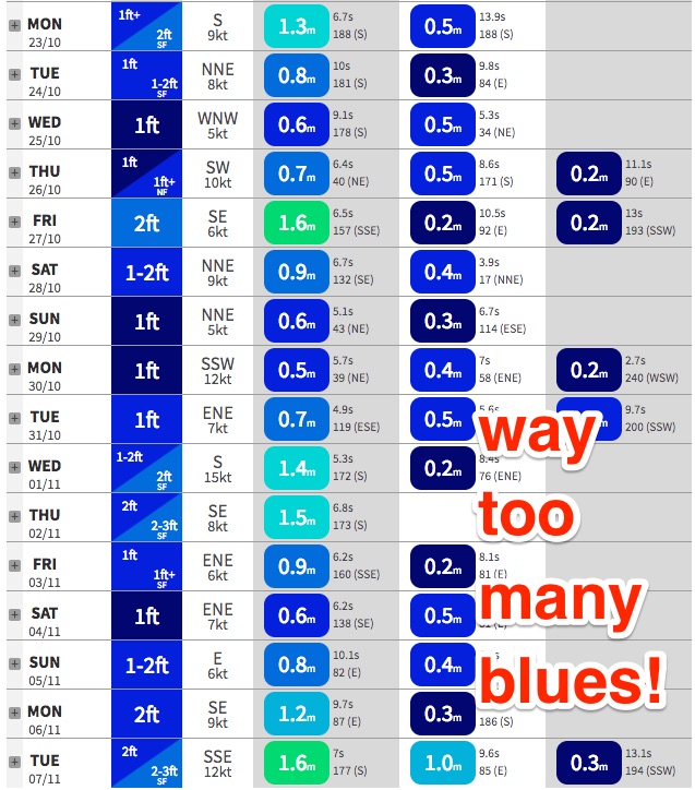
Hey Thermalben, quick question - what's the purpose of a secondary and tertiary swell? I understand why we look at primary (and the correlation between low seconds intervals being wind swell and higher seconds intervals being groundswell), but not sure of the function of Secondary and Tertiary measurements.
Cheers!
At any one time, there can be multiple swell trains in the water.
The primary swell train is essentially the largest, but this doesn't necessarily generate the biggest surf (because surf size is proportional to swell height, period and direction relative to a local beach).
So, if we displayed just the primary swell train - as a lot of websites do - then it wouldn't tell the full story. More times often than not, the secondary (or even tertiary) swell train will be the energy delivering the goods at your local beach.
More reading:
https://www.swellnet.com/forums/crystal-ball/39001
https://www.swellnet.com/news/swellnet-analysis/2013/10/21/understanding...
https://www.swellnet.com/news/swellnet-analysis/2013/10/25/south-facing-...
Ah beauty, thanks!!