Waves ahead, but hard to muster enthusiasm
Sydney, Hunter and Illawarra Surf Forecast by Ben Matson (issued Friday 13th October)
Best Days: No great days due to poor winds.
Recap: Wednesday’s downgraded forecast for Thursday’s NE windswell wasn’t quite enough.. exposed NE facing beaches pulled in 2ft+ sets and remaining beaches were tiny, though clean with early offshore winds. A small S’ly expected today hasn’t really produced anything of any great quality, though interestingly, there are some fun lines showing across the Mid North Coast (north of our forecast region). South facing beaches in Southern NSW have managed slow 2ft sets but elsewhere it’s been very small and weak.
This weekend (Oct 14 - Oct 15)
The weekend looks pretty craptacular.
A building ridge of high pressure through the southern Tasman Sea will drive gusty S/SE winds into the Southern NSW through early Saturday morning, rendering all but the most protected beaches bumpy and choppy (and, protected spots will be tiny).
As for surf, today’s southerly swell will be all but gone, to be replaced by a couple of small building long period southerly swells generated by broad but unfavourably aligned lows and fronts tracking south of Tasmania yesterday and today. We’ll see very inconsistent 2-3ft sets at south facing beaches into Saturday afternoon (smaller early) with possibly a few larger sets through Sunday, and it'll be slightly bigger overall across the Hunter. However, any potential quality in these swells will be masked by the bumpy onshore conditions.
Saturday's gusty winds will also kick up some local windswell for the afternoon though probably not a great deal more than what’s expected in the form of inconsistent groundswell.
Sunday will see the onshores ease back though it’s unlikely we’ll see a major improvement in surface conditions, with the airstream expected to remain out of the eastern quadrant. However, the pressure gradient will ease off across the South Coast so it’s certainly possible we’ll see light variable winds south of Sydney at times. But from Sydney to the Hunter coast, it’s certainly not looking too flash with moderate onshore winds the most likely scenario. There’ll be a small undercurrent of E’ly windswell plus the intermittent southerly groundswell, so keep your expectations low if you’re looking for waves this weekend.
Next week (Oct 16 onwards)
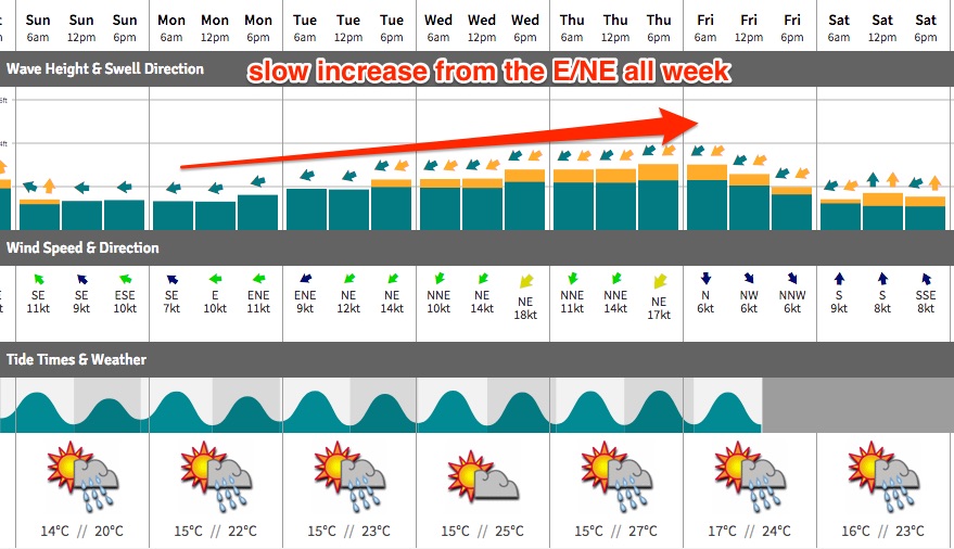
Next weeks's synoptics look much more late summer than mid-spring, with a slow moving high pressure system in the southern Tasman Sea and a developing trough off the Central Qld coast. This will strengthen E’ly winds into SE Qld and Far Northern NSW, though unfortunately Southern NSW will reside just below the fetch’s alignment so we’ll see a small spread of short range swell fill into our region.
Additionally, it looks like winds will start out of the east, but then remain out of the NE quadrant for the rest of the week. Not only will this keep surface conditions below par, if we see enough sustained strength it’ll instigate a bout of cold water upwelling.
Anyway, there will be waves all week. The weekend’s south swells will ease quickly, to be replaced with a combination of short range E’ly thru’ NE windswell. Monday should see size around the 2ft mark, building to 2-3ft into Tuesday and Wednesday with Thursday possibly seeing some bigger waves, ahead of an easing trend throughout Friday.
So, we’ve got a whole week of technically surfable conditions ahead but there’s nothing of any great quality on the charts. Let’s take a closer look on Monday.
Have a great weekend!


