Fun clean S'ly swell Friday, a couple of windows for the weekend
Sydney, Hunter and Illawarra Surf Forecast by Craig Brokensha (issued Wednesday 13th September)
Best Days: Friday, Saturday morning south magnets, Sunday morning, Monday morning south magnets
Recap
A further drop in S/SE swell yesterday from 2-3ft across south facing beaches, back to a smaller 1-2ft this morning, mixed in with a NE windswell. Early light winds have since freshened out of the west, bringing rising hot temperatures.
This week and weekend (Sep 14 – 17)
These notes will be brief as Ben’s away today.
It looks like we'll be starting off from a tiny base tomorrow morning with a trickle of tiny NE swell energy not getting above 1ft. During the day, a distant SE swell is expected to show across south swell magnets, generated by a good fetch of SE gales south of New Zealand earlier this week.
Sets aren't expected to top an inconsistent 2ft and conditions and gusty W/SW winds will favour open beaches which will be small to tiny.
Later in the day we should see some new S'ly energy pushing up the coast, produced by a small fetch of strong W/SW winds exiting eastern Bass Strait this evening, moving up the southern NSW coast through the day.
No size is expected until the last hour or so of light, with 2-3ft sets possibly showing at south magnets on dark. With the timing of the swell, the Hunter is likely to come in a similar size on dark.
Friday looks like a better day to surf with a further increase in mid-period S'ly swell from stronger W/SW-SW gales exiting eastern Bass Strait tomorrow afternoon.
South facing beaches should build to 3-4ft+ through the day (most likely afternoon), a bit smaller through the morning, while the Hunter region is expected to see building sets to 4-5ft+.
Winds are looking favourable and offshore all day with a persistent fresh W'ly (even tending W/NW at times across selected locations).
The weekend (Sep 16 - 17)
 The surf should ease back into Saturday as winds relax in our swell window from Friday afternoon, with quickly easing 2-3ft sets across south magnets at dawn, small to tiny into the afternoon. The Hunter should see a touch more size, but by the afternoon expect small surf.
Conditions will be great for south facing beaches with a moderate to fresh W/NW breeze, but a S/SW change is due early afternoon, linked to another cold front pushing across the south-east of the country.
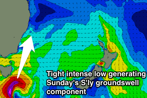
This front will actually have a very tight and intense embedded low attached to it, with a quick burst of severe-gale to storm-force SW winds due to be aimed through our southern swell window, off the south-east of Tasmania.
This will be along with a broad fetch of strong SW winds being projected up the southern NSW coast Saturday afternoon and evening.
What we should see is some mid-period S'ly swell for Sunday morning, with some S'ly groundswell filling in around the same time.
South facing beaches are likely to come in around 3-4ft most of Sunday but there's likely to be some bigger ones in the mix (5ft+) with the longer-period S'ly groundswell. The Hunter should see surf more to 4-5ft with 6ft bombs.
Winds won't be ideal for south magnets with a W/SW tending S/SE breeze, so hit the open beaches through the morning.
Into Monday we'll see the S'ly swell energy easing with early light NW winds and gusty NE sea breezes, kicking up a small NE windswell for Tuesday morning. More on this Friday though.


Comments
NUP...swell dropped off.
Looks like we're in between pulses this morning. We've got a new swell pulse due this afternoon still.
Also as you can see there are sets out there (guy taking off on left closeout), just a bit of a wait..