Extended spell of small waves for Sydney surfers
Sydney, Hunter and Illawarra Surf Forecast by Ben Matson (issued Monday 3rd July)
Best Days: Tues: get in quick for the last of today's SE swell. Late Thurs / early Fri: flukey south swell, probably just at south swell magnets, biggest in the Hunter.
Recap: The weekend generally came in as expected - a large S’ly swell Saturday, ahead of a strong secondary S/SE on Sunday.
However whilst Saturday's S’ly swell came bang on expectations, Sunday's secondary S/SE swell came in bigger than forecast across several coasts - I only expected the Hunter region to be pushing 6ft+ (with Sydney and locations further south forecast to be around 4-5ft), but many regions north from Wollongong also reported 6ft+ bombs. Conditions were great both days with offshore winds in general.
This swell has eased back steadily into this morning, with early offshore winds giving way to moderate northerlies. A reinforcing SE groundswell has maintained 3ft+ surf across most open beaches throughout the day - we certainly haven’t seen a pronounced kick in new energy, but the fact that the surf hasn’t lost any more size since this morning (via observations, and buoy data) supports the expectation for a new pulse of SE swell some time today.
The big question now is: how long will this final pulse last?
This week (July 4 - 7)
We’ve got a spell of generally small surf ahead.
The Southern Ocean storm track is gaining strength through the Bight but it’s too north in latitude and too west in longitude to be in any way favourable for us.
Our current SE swell will ease steadily through Tuesday morning and this will certainly be the best time to surf. Exposed south facing beaches (mainly north from Sydney to the Hunter) should see early 2ft, maybe 2-3ft sets right on dawn, clean with moderate NW winds, but they’ll ease to 1-2ft throughout the day (expect smaller surf elsewhere). The models have this swell easing pretty quickly overnight tonight, so I can’t rule out the chance that we see more size lost before dawn than expected - so keep your expectations low, especially with the continuing downwards trend.
In Friday’s notes I mentioned that a strong front exiting eastern Bass Strait on Tuesday could set up an acute south swell for Wednesday, but I also noted: “however, these swell sources rely critically on the fetch alignment - if it tends any more west, we’ll see no surf at all; but if it veers SW then we’ll see more size.”
Unfortunately the models have tilted the fetch W thru’ W/NW, which means no new swell for us at all.
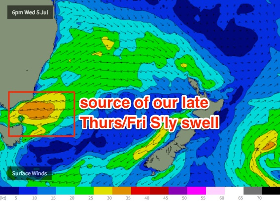
However the low will eventually push into the Tasman Sea, displaying gale force W/SW winds through Wednesday that will rebuild S’ly swells for Thursday. It’s looking to be rather touch and go on the periphery of our swell window, but exposed south swell magnets (particularly those across the Hunter) should see a decent pulse from Thursday lunchtime/early afternoon onwards, reaching 2-3ft+ sets across the Sydney region late afternoon, bigger up to 4ft just before dark across the Hunter. Expect smaller surf elsewhere due to the direction, and we may see slightly less size across the South Coast due to its proximity to the spread axis.
This swell will peak overnight (ain’t it always the case?) and trend down through Friday. Early morning should see a similar size range as per late Thursday but it’ll be on the way out so aim for an early surf.
As for conditions, the whole week will be clean with varying strengths form the western quadrant as these fronts slip by to the south.

This weekend (July 8 - 9)
Friday’s south swell will disappear by Saturday, leaving us with tiny conditions to start the weekend.
A strong front crossing the coast around the same time looks like it’ll be positioned too far north to benefit us - initially there’ll be very little fetch inside our swell window (all W/SW, but north of eastern Bass Strait so too short in length to favour NSW swell generation).
However a secondary fetch developing off Tasmania’s East Coast on Saturday may generate a small south swell for Sunday, possibly some afternoon 2ft+ sets at south swell magnets, but hardly anything elsewhere.
That’s about it. At least it’ll be clean with offshore winds.
Next week (July 10th onwards)
The models maintain a similar progression off Southern Ocean lows through next week, though at more southern latitudes which opens up the prospects of a better, longer lasting southerly groundswell event through next week. It’s still early days though.


Comments
Spring conditions and a stunning sunset in Manly this evening..