Easing swells, funky winds
Sydney, Hunter and Illawarra Surf Forecast by Ben Matson (issued Friday 9th June)
Best Days: No great days owing to tricky winds. But Saturday will have the most size out of the east. Possible fun small but long period S'ly swell later Wed/Thurs.
Recap: Easing S/SE swell Thursday morning gave way to a new building E’ly swell Thursday afternoon. Size hovered around the 4ft mark late in the day though eased a little today. Winds have been funky at times, periods of light variable winds (even W’lies in parts) alternating between onshores.
This weekend (Jun 10 - 11)
A slow moving easterly fetch across the southern flank of a Tasman Low - positioned off the Mid North Coast - is slowly weakening and contracting to the north.
This is our current source of easterly swell for the region, so as it exits our swell window we’ll see a gradual easing of the source fetch and thus a slow drop in surf size.
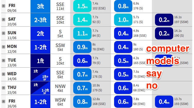
With today’s wave heights coming in a little undercooked, I have downgraded the weekend’s size potential. Most open beaches between the Gong and Hunter coasts should see 2-3ft+ sets through Saturday (biggest in the north), easing to 2ft+ during the day and further from 2ft to 1-2ft on Sunday.
A tiny long period south swell will also grace the coastline over the weekend but it’s not expected to deliver much size at south facing beaches, maybe a few stray 2ft sets through Saturday afternoon and Sunday. With average winds it won't be worth too much attention though.
Winds look funky as we’re likely to see a lingering onshore flow associated with a slowly building high pressure ridge to the south. There should be periods of light variable winds at times but the onshore will be quite prevalent in most regions.
So on the balance - you'll get wet, but your Instagram feed will be a little light on local content.
Next week (Jun 12 onwards)
 Yet more curveballs regarding next week’s synoptic developments. And with such massive swings from model run to model run, we really need to keep our expectations low for now.
A developing trough and low is likely somewhere on the East Coast next week though the latest guidance focuses all of this activity well up north, and outside of our swell window. So for now I am ignoring this system as a possible source of quality surf next week - though it certainly can’t be ruled out (especially into the long term towards next weekend).
A series of deep but poorly aligned Southern Ocean lows traversing the waters south of Tasmania in recent days and over the weekend will set up a succession of small long period groundswells for the first half of next week.
In general these systems - though very powerful, and in some cases quite broad in coverage - are simply too far away or too poorly aligned to benefit out region with any appreciable size. So I’m not expecting anything significant in the surf department for the time frame between Monday and Wednesday morning - small pulses at south facing beaches in the order of a foot or two at times, but without any major size, strength or consistency.
However the storm track aligns more meridionally (north/south) later Monday and Tuesday, setting up a better south swell for Wednesday afternoon and Thursday that could reach 3ft+ at south facing beaches in Sydney, and a little bigger in the Hunter.
This is still some time away though so let’s check back on Monday to see what fresh curveballs have been thrown our way.
Other than that there’s nothing of any major interest. The models redevelop a coastal trough along the NSW coast at the end of their runs, but then again the’ve been doing that for the last week or so, and as such we need to take those kinds of projections with a grain of salt.
Have a great weekend, see you Monday!

