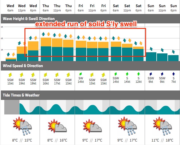
Windy for the next few days; improving steadily over the weekend
Sydney, Hunter and Illawarra Surf Forecast by Ben Matson (issued Wednesday 31st May)
Best Days: Sat: strong, easing S/SE swell with improving conditions. Sun: lighter winds with smaller S'ly swells.
Recap: Tiny clean south swell Tuesday, building steadily today though accompanied by gusty SW tending S’ly winds.
This week (Tues 30th - Fri 2nd)
I’m a little less excited about Friday than I was on Monday.
Both days were always expected to see wind affected, short range southerly swell with gusty S/SW winds. But Friday had the possibility of a slightly bigger, longer period S/SE pulse, originating from the core Tasman Low undergoing an intensification through Thursday as it tracked north.
This development has been slightly weakened in the latest model runs.
We’re still looking at a broad, lengthy southerly fetch - by Thursday afternoon stretching from southern Tasmanian latitudes right up to New Caledonia, which is very impressive - but overall wind speeds will be mainly around the 30kt mark and this will by and large reduce prospective swell periods by a couple of seconds. It’ll also smooth out any peak in new energy, blending both days into one timeline rather than providing a noticeable ‘kick’ from a new event at a particular point in time.
Anyway, the broad picture is somewhere around 5-6ft sets at south facing beaches both days, slightly bigger in the Hunter, but smaller at those locations that can handle breezy S/SW winds. I still think there’s a chance for isolated pockets of SW or even W/SW winds at dawn both mornings but this will be confined to a handful of venues at best.
Winter is here!
This weekend (Sat 3rd - Sun 4th)
 The weekend’s easing trend now looks like it’ll occur more slowly than previously though, though it’ll be steadily down nonetheless.
Friday’s strong energy should still manage 4-6ft sets at south facing beaches early Saturday morning, before easing to 3-5ft during the day and Sunday will ease from 3-4ft to 2-3ft.
Expect a little more size across the Hunter, but (as per usual) smaller surf at beaches with less southerly exposure.
The downside of the slightly elevated weekend surf prospects is that Saturday now has an increased risk of lingering S/SE flow. Most locations south of Sydney should be around to a W/SW breeze but from Sydney north - and especially through the Hunter - we are likely to see somewhat lumpy conditions to start the weekend, possibly breezy.
Sunday looks really nice overall though with light variable winds in most areas. There’s still a chance for a lingering S’ly through the Hunter on Sunday but I’ll have more on that in Friday’s update.
Next week (Mon 5th onwards)
A small but strong polar low passing south of Tasmania on Friday may set up a minor south swell for early next week, and its latter incarnation off New Zealand’s South Island (West Coast) may kick up a small SE thru’ E/SE swell at points throughout the middle to later part of next week (the model data isn’t strong at the moment, so confidence isn’t high).
Otherwise, we’re looking at a cold outbreak across the eastern states next week, though this could be positioned anywhere between NSW/Vic and SA - of which the resulting synoptic flow axcross Southern NSW could tip in any direction. There’s no suggestion for any major swell generating developments in the Tasman Sea at this point in time so let’s have a closer look on Friday.


Comments
Decent bowl at Cronulla Point a short time ago.