Smallish south swell for the weekend; next round due Wednesday onwards
Sydney, Hunter and Illawarra Surf Forecast by Ben Matson (issued Friday 28th March)
Best Days: Sat: small clean S'ly swell. Sun: OK options in the PM with easing winds and a building S'ly swell.
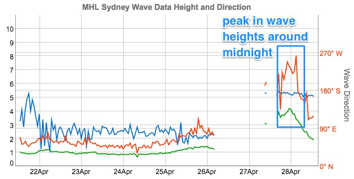
Recap: Strong S’ly swells built during Thursday, with mainly fresh W/SW thru’ SW winds. Overnight winds swung S/SW so this morning’s early conditions were remotely bumpy across many locations, but we’ve seen a return to a W/SW flow throughout the day, even W’ly in some regions. Wave heights have steadily eased since a peak around midnight last night.

This weekend (Apr 29 - 30)
Wave heights peaked overnight Thursday, around six to eight hours earlier than expected, which is a shame - the Sydney buoy shows that Hsig reached 4.18m around 11pm, with Hmax nudging 8.05m around 3am. Hard to estimate how might that may have been with no visual confirmation, but 6-8ft+ south facing beaches seems very likely.
Since that time, wave heights have dropped like a rocket - by dawn this morning, Hsig values were down to 2.9m and the last reading (2pm) is at 1.8m. That’s a drop of more than 2m in 12 hours, which is very unusual. It’s also a little more rapid than model guidance (and my own expectations) anticipated.
Anyway, because of this rapid easing trend, I have slightly pegged back my expectations for Saturday’s surf. We are still looking at some new energy spreading northward from a band of W/SW gales exiting eastern Bass Strait, but this fetch is not expected to develop properly until overnight tonight and I don’t think it’ll reach the Sydney region until later in the day.
South facing beaches should see inconsistent 2-3ft sets on Saturday morning, possibly easing in size through the middle of the day ahead of the new energy which should provide a late kick back up into the 2-3ft range at south facing beaches.
Conditions will be clean under a light to moderate W/SW flow but beaches with less southerly exposure will be considerably smaller. The Hunter should see occasional bigger sets though.
On Sunday, we’ll see this new S’ly swell double up with a secondary south swell, originating from a cold front passing south of Tasmania tonight (somewhat related to the W/SW fetch exiting eastern Bass Strait, though much further south so therefore a longer travel time).
This should build wave heights from 3ft to 3-4ft throughout the day at south facing beaches. Winds will initially freshen from the S/SW as the front clips the coast but they’ll ease off into the afternoon (and probably swing S/SE), providing workable conditions later in the day. This is good timing as it’s when we’re likely to see the biggest surf from this next round of energy.
Once again, beaches not directly open to the south will be smaller but the Hunter should pick up some bigger waves.
So, aim for a late surf on Sunday if you can as it’s looking to produce the best surf of the day.
Next week (May 1 onwards)
Surf size will ease steadily through the start of next week. There’s a few flukey systems on the periphery of our swell windows (a polar low, plus a system off the NZ West Coast) but none appear to be in a position to generate any meaningful energy so right now I’m going to discount them as quality sources of new surf.
Monday should offer clean conditions early morning before freshening northerlies spoil the party (inconsistent 2-3ft south facing beaches at dawn easing to 1-2ft during the day); Tuesday will be super clean under pre-frontal W/NW winds though surf size will be very, very small by this time.
The next round of south swell will kick in from Wednesday onwards. Initially, short range energy will make its presence felt as a front pushes up the coast, but into the afternoon we’ll see some new long period energy from a polar low developing S/SW of Tasmania on Sunday.
This system will develop right on the periphery of our southern swell window - and a long distance from the mainland too - so it’s not worth getting too excited about. And local winds will probably trash conditions at south facing beaches during Wednesday, but as a source of swell, it is worth noting in the event the local wind forecast improves between now and Monday’s updated notes.
Otherwise, we’re looking at strengthening S/SW winds through the entire Tasman Sea next week between an NZ low and a high west of Tasmania. This should generate anywhere between 4ft and maybe 6ft of mixed quality south swell, centered around Thursday, easing into the weekend.
Have a great weekend.. see you Monday!


Comments
Coupla nice pre-dawn peaks at Maroubra.