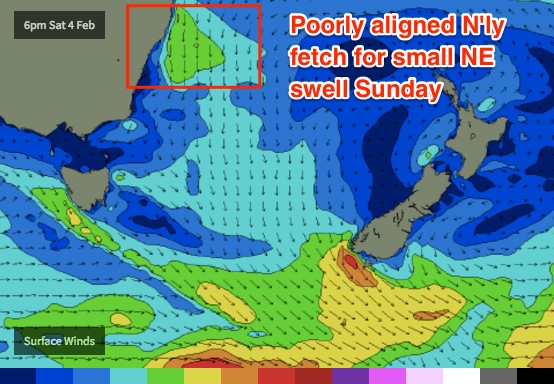
Not much activity across Southern NSW
Sydney, Hunter and Illawarra Surf Forecast by Ben Matson (issued Wednesday 1st February)
Best Days: No great days due to a continuation of small swells.
Recap: Monday’s building NE swell reached 3ft through the late afternoon, but unfortunately buoy data shows that the energy peaked around midnight before easing rapidly through the early hours of the morning. As such, Tuesday morning came in below forecast expectations (2ft+ at the swell magnets at dawn, and pretty weak) and size continued to drop during the day, with early light winds swinging gusty S’ly around lunchtime. Today we’ve seen a mix of swells from the south and north-east, with light to moderate S’ly winds. The south swell has come in a little bigger than expected with some 2ft+ sets but it's not particularly inspiring.
This week (Jan 31st - Feb 3rd)
Look, I can go into comprehensive detail about the synoptic for the next few days, but in short we’re looking at a continuing period of small weak surf.
There’s simply no major weather activity in the Tasman Sea, the Southern Ocean storm track is aimed away from our coast and the trade belt that’s starting to form across the Northern Tasman and South-western Pacific has yet to develop into an appreciable fetch worthy of any notable size or energy.
Local winds should be some degree of variable both morning, if anything trending southerly through Thursday then north-east through Friday. But expect small, slow surf at swell magnets as your only rideable option.
This weekend (Feb 4th - 5th)
A small N’ly fetch will develop off the Mid North Coast from Friday through Saturday and although poorly aligned for our region, should generate a small NE windswell for late Saturday and into Sunday. Perhaps 1-2ft at reliable NE swell magnets and bugger all elsewhere, including the northern Hunter as it'll be partially shadowed from the Hunter curve.
Sunday may also see a small distant pulse of S/SE swell from a stationary polar low anchored in the same position as a series of similar polar lows in recent weeks. However the small fetch length and large travel distance will keep a lid on surf size and consistency. I’d be surprised if we saw much more than a foot or two through the afternoon at south swell magnets, but it’s also worth mentioning that the models have the swell building to 0.6m @ 14.8 seconds, which suggests a little more size than that. Let’s wait and see how the ASCAT pass looks on Friday.
Winds should retain some variable component this weekend but there's certainly a risk for northerlies, especially north of the Illawarra.

Next week (Feb 6th onwards)
The long term outlook is still on the quiet side.
Monday should see a peak in S/SE swell from the polar low; at this stage I’ll peg size at an inconsistent 2ft+ but will await satellite confirmation over the coming days.
We’ll also see some small NE swell from the anchored N’ly fetch off the Mid North Coast though no major size is likely from this source.
Early next week will also see the start of a small, steady uptick in E/NE swell from the developing trade flow north of New Zealand but again, no major size is expected do the the modest wind speeds and fetch width. However, this source should supply a small undercurrent of energy for most of next week.
So, the waiting game continues for a major swell event to kick off the year. Tune back in on Friday to see if there’s been an improvement!


Comments
Thanks Ben! Let's hope something kicks up soon! I'm now willing to travel in order to get a wave or two!
Anyone else seeing a small twinkle of hope for extreme south swell magnets tomorrow from the WSW fetch in bass strait?
I agree Manly South. I travel for work and have been seriously considering jumping on a plane interstate. But the usual swell magnets are all crap this weekend as well?
Telo islands for a long weekend...
Now ya talking.