Small swells and tricky winds this week
Sydney, Hunter and Illawarra Surf Forecast by Ben Matson (issued Monday 2nd January)
Best Days: No amazing days but there'll be small peaky beachies Wed (SE) and Thurs/Fri (ENE) worth your a quick early paddle.
Recap: Small easing NE swells on Saturday became tiny on Sunday, and a small S’ly swell on Sunday also remained at tiny levels. Today we started off with tiny waves and a gusty southerly wind change just before dawn. Surf size has built steadily since then and south facing beaches now have 3ft sets at south facing beaches, but the waves are only small elsewhere.

Building southerly windswells at Bondi this afternoon
This week (Jan 3rd - Jan 6th)
Since Friday’s outlook, the models have made a few changes to the synoptic specifics for today.
Although the southerly change that arrived this morning has now pushed across the North Coast, a small secondary low off the Tasmanian East Coast (not previously modelled) is expected to follow closely behind, reaching the Far South Coast later today and the Sydney region overnight.
Wind speeds around this secondary low aren’t high, but the small fetch will be working on an active sea state generate by today’s change. So this should assist in nudging up wave heights from what’s an otherwise unremarkable fetch. South facing beaches should see 3ft to almost 3-4ft sets at times, but due to the straight S’ly swell direction, beaches not open to the south will be much smaller.
Local winds will not do us many favours though. We’re looking at fresh and gusty S’ly tending SE winds throughout the day, with only a remote chance for brief localised periods of lighter SW winds around dawn (probably the Northern Beaches, and not many other locations). So, keep your expectations low (winds should be lighter south of the Illawarra though).
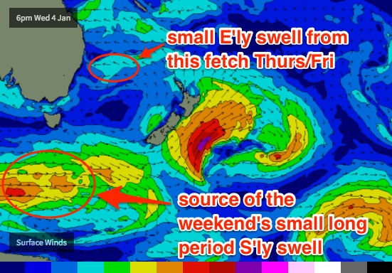
A building high pressure ridge in the southern Tasman Sea on Wednesday will drive moderate easterly winds across our coast. Tuesday’s southerly swell will have eased right back by this time, but the ridge should generate 2-3ft of short range E’ly swell. This will swing more E/NE on Thursday as the high pushes to the NE (closer to New Zealand’s North Island), tweaking the fetch’s orientation.
Also arriving across the South Coast on Tuesday afternoon will be an unusual SE swell generated by a slow moving trough south of New Zealand over the weekend. This swell will fill into Sydney beaches overnight, and should provide 2-3ft sets at south facing beaches into Wednesday. It’s a shame local winds won’t be especially favourable as this swell could have generated some useful surf at a bunch of reefs that prefer this swell direction. But, winds should be light (and possible variable) early morning so we may see some fun lumpy surf across many coasts.
This combo of SE and E tending E/NE swells will then ease slowly through Thursday and Friday with mainly light winds under a broad coastal troughy pattern. There is a suggestion for a mild intensification of a E/NE fetch within our immediate swell window onto Thursday (which could produce a minor increase into Friday) but it’s early days. Let’s take a closer look on Wednesday.
This weekend (Jan 7th - Jan 8th)
A deep Southern Ocean low is expected to intensify well to the SW of Tasmania around Tues/Wed of this week, before weakening and tracking up towards New Zealand.
Although unfavourably aligned for our coast, we should see some small long period south swell glance the coast on Saturday. Only south swell magnets will pick up any size; at this stage I’m banking on inconsistent 2ft+ sets with another foot or more through the Hunter. The breaks between sets will be considerable too, and this swell will ease through Sunday.

Also in the water on Saturday will be some small short range E/NE swell from the modest ridge through the central Tasman Sea, again with size around the 2ft+ mark, possibly a smidge higher. Although not very strong, these kinds of low period swells can sometimes produce fun surf at open beaches. Let’s see how the models are resolving things on Wednesday.
Otherwise, freshening N/NE winds through Saturday should kick up a small short range swell for the afternoon and into Sunday. No major size is expected from this source at the moment.
Local conditions look like they’ll be cleanest early Saturday before the N/NE breeze develops, and then possibly Sunday morning with an early NW wind ahead of the redeveloping N/NE’er.
Next week (Jan 9th onwards)
The models are starting to firm up on some decent tropical activity in the Coral Sea next week as the monsoon trough tracks across the north of the country.
A building ridge through the Northern Tasman Sea this weekend should generate some small sideband trade swell for our region early/mid next week, but of much more interest (initially to SE Qld surfers) is a possible tropical low west of New Caledonia that could develop into a significant swell generating system. I'll be keeping a very close eye on this over the coming days: more in Wednesday’s update.


Comments
Rather craptacular across the coast but at least there are waves!
Chunky but otherwise unremarkable onshore surf at Bondi, with sets in the 3ft, nearly 3-4ft range.