Plenty of small swells from the E/NE ahead
Sydney, Hunter and Illawarra Surf Forecast by Ben Matson (issued Wednesday 21st December)
Sign up to Swellnet’s newsletter and receive the Sydney/Hunter/Illawarra Forecaster Notes and latest news sent directly to your inbox. Upon signup you'll also enter the draw to win a surf trip to P-Pass for you and a mate. It doesn’t get much easier so click HERE to sign up now.
Best Days: Thurs: early light winds and a fun mix of S'ly and small E/NE swell. Fri: early light winds and a fun small E/NE swell (and some small leftover S'ly swell). Xmas Eve/Xmas Day/Boxing Day: fun E/NE swell and a small NE windswell, aim for an early surf whilst winds are lighter.
Recap: Tuesday’s S’ly swell offered very occasional 3ft+ sets at south facing beaches (bigger in the Hunter) but for the most part surf size was around the 2-3ft range. Winds freshened from the N/NE throughout the day ahead of a gusty S’ly change that reached Sydney just before midnight. Unfortunately as expected the fetch trailing this change was basically non-existent so we’ve seen only small residual swells and light to moderate S’ly winds today.
This week (Dec 22nd - 23rd)
We’ve got a couple of swells due on Thursday.
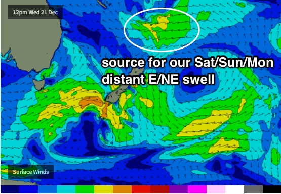
First of all, a small long range E/NE trade swell generated by a stationary tropical depression near Fiji over the weekend is generating small levels of distant energy that will slowly build over the coming days towards a peak on the weekend. No great size is expected but we should start to see rogue 2ft sets at most open beaches throughout the day.
Additionally, the parent low to last night’s S’ly change tracked SE of Tasmania today, with SW gales about its northern flank. They’re not very aligned within our swell window but a small southerly groundswell is still expected to glance the coast throughout the day.
It’s hard to be confident in the size range; the fetch length is quite good, with an almost stationary band of gales occupying the same part of our swell window for a decent period of time, however their off-axis alignment is concerning. What this will probably result in is a limited spread of southerly swell to a handful of reliable south swell magnets - so don’t be surprised if a seemingly reliable south facing beach doesn’t quite perform to expectations. 2-3ft sets is certainly the upper range for the south swell magnets across Sydney beaches (with much smaller surf elsewhere, mainly E/NE swell) but the Hunter should see a few bigger waves from the south.
Expect a peak during the middle of the morning with an easing trend late in the afternoon. Winds should be mainly light; early offshores tending onshore after lunch.
Thursday’s southerly swell will then ease into Friday, but the E/NE swell should continue to provide small intermittent sets at beaches facing NE, with size around the 2ft mark. Expect very long breaks between waves. Winds will freshen from the NE but we should see an early period of variable conditions.
This weekend (Dec 24th - 25th)
No changes to the weekend outlook.
We’ll see a very slow increase in E/NE trade swell both days but the sets will remain very inconsistent across the region, up around 3ft by Sunday. Freshening NE winds will create bumpy conditions at most beaches; there’ll be a period of lighter N’ly winds at dawn but it’s likely both days will see a persistent northerly wobble through the lineup. It's also worth reiterating just how inconsistent the sets will be - expect very long breaks between the bigger waves.
These NE winds will also kick up a small NE windswell over the weekend but this will be smaller than the pre-existing E/NE trade swell.

Next week (Dec 26th onwards)
The long range forecast looks much the same as it did in Monday’s notes.
Freshening NE winds will further build a local NE swell across the coast on Monday, and the E/NE trade swell should persist around the 3ft mark. So, it'll really be just a continuation of Sunday’s conditions with perhaps a smidge more NE windswell.
At this stage the NE coastal flow is expected to remain anchored across our region (continuing short range NE swell into Tuesday and Wednesday), and a new ridge will build across the northern Tasman Sea. Our long lived E/NE swell (expected to peak on Sunday) will ease from Monday afternoon onwards, but this building ridge to the north will rebuild fresh short range E/NE swell through the middle of the week.
In fact, the models have a new tropical low developing south of New Caledonia mid week that could up the ante with a stronger E/NE swell towards the end of next week, but that’s still quite some time away. But, for all intents and purposes we are certainly looking at an extended run of activity out of our E/NE swell window, which is only a good thing. South facing beaches could be a little quiet for the next couple of weeks.
See you Friday!

