Flukey swell sources this week; possible large S'ly swell on Sunday
Sydney, Hunter and Illawarra Surf Forecast by Ben Matson (issued Monday 15th August)
Best Days: No great days to be sure about, due to flukey swell sources. There is some potential on Tues with a long period south swell, and maybe Fri with a small SE swell, plus a combo of S swells for Sun that could become quite sizeable.
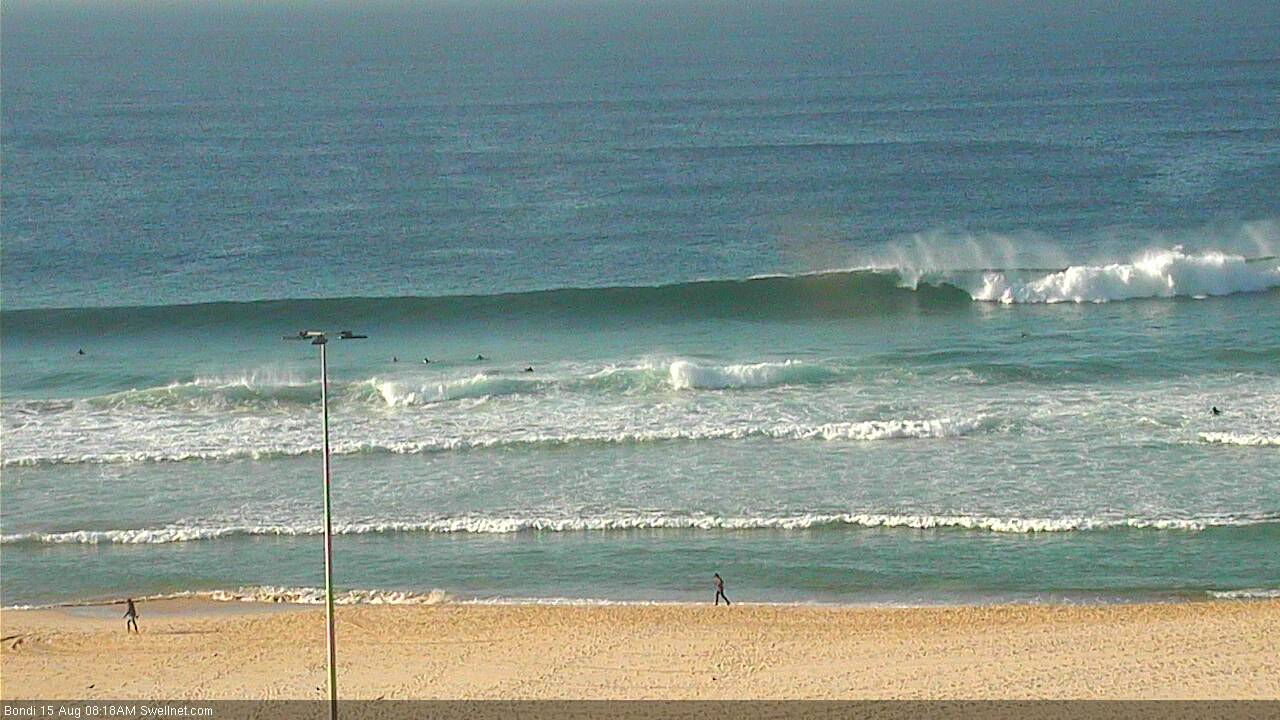
Recap: Surf size remained very small over the weekend, with Saturday seeing minor residual energy across the coast. A small increase in small south swell expected Sunday afternoon came through earlier than expected, providing clean 2ft sets at south facing beaches throughout the day, however this was superseded by a stronger southerly groundswell that peaked around 3-4ft across south facing beaches this morning (see Bondi surfcam grab below), before easing throughout the day. Conditions generally remained clean all days with light offshore winds.

Bondi had some strong sets this morning. Watch it live here.
This week (Tues 16th - Fri 19th August)
With today’s south swell on the way out, we have to look towards fresh sources of new energy for the coming days. The outlook isn’t great, but there are some possibilities on the cards.
Late last week, a very powerful mid-latitude low developed SW of Tasmania, displaying core wind speed of 50kts+. Although the fetch was poorly aligned within NSW's acute south swell window, we can’t discount some of this energy spreading back into Southern NSW as it rounds the Tasmanian corner.
The leading edge of this swell - with peak swell periods of 18+ seconds - is likely to glance the coast overnight tonight, before the primary groundswell signal filters in throughout the day, probably peaking into Tuesday afternoon.
Confidence is only low as to how much size we’ll see, due to the unfavourable position of these winds relative to the NSW coast, but there is certainly the potential for south swell magnets in Sydney to pick up very inconsistent 2-3ft sets (starting from a smaller base early morning).
The Hunter coast is often more reliable under these flukey south swells, so bigger waves are possible here to 3-4ft. I would expect there to be very long breaks between waves though, and beaches not open to the south will once again be considerably smaller, especially so across locations south of Wollongong.
Local winds should be relatively favourable on Tuesday, mainly some form of north-west breeze however periods of northerly winds can’t be ruled out. So you’ll need to hit up protected northern corners for the best conditions.
On the balance, I wouldn’t recommend a road trip or any time off work due this being such a low confidence swell, but keep an eye on the Bondi cam to monitor the day’s trend, as it’ll pick up this south swell the best.
Other than that, it looks like we’re heading towards a quiet period on the surf front for the rest of the week thanks to a blocking high across the Tasman Sea that’s both shunting Southern Ocean fronts back down towards the ice shelf, and also inhibiting any major developments in our east and north-east swell windows.
A broad ridge currently developing across the Northern Tasman Sea and Coral Sea will be aimed too far outside of our swell window to benefit Southern NSW.
The only other interesting source of new energy is a slow moving trough across the Southern Tasman Sea from Wednesday onwards that may develop a thin SE fetch; probably best aimed into Tasmania’s East Coast but it could provide a small SE swell to finish the week (if anything, biggest on the Far Southern NSW Coast). I’ll have more details on that in Wednesday’s notes.
This weekend (Sat 20th - Sun 21st August)
A couple of sources have potential for the weekend, but it’s early days and the models are in disagreement about the particulars so we need a few more days to develop any confidence.
Aside from the weak troughy pattern across the Southern Tasman Sea (that may generate a small SE swell for Fri and/or Sat), we are expecting a second slow moving trough north of New Zealand throughout the week that may align itself within our swell window around Thursday. Current projections are that it’ll be a brief turn of events without any major strength (so the surf potential is rather low), but nevertheless it’s worth monitoring over the coming days for a possible small E/NE swell throughout the weekend.
Otherwise, the models are suggesting yet another strong winteresque frontal progression across the SE corner of the state later this week, with a powerful low developing S/SW of Tasmania around Friday. This should set up a small, long period southerly swell around Sunday.
At the same time, it looks like we may see an intense cut-off low form east of Bass Strait - around Saturday or thereabouts - which could very well generate a much bigger, mid-range south swell for Sunday (in addition to the underlying long period energy mentioned above). Local winds would probably be quite gusty from the SW quadrant but it certainly looks like our spell of small waves will probably come to an abrupt end on Sunday, from several potential sources. More on this in Wednesday’s notes.
Next week (Monday 22nd onwards)
Sunday's cut-off low in the Tasman looks like it’ll dominate our region for a few days, so the first half of next week looks equally activate with solid south swells a very good possibility at this stage. Additionally, we may see some E/NE swell originating from the troughy infeed to the east (related to the same system).
Either way, the long term has lots of exciting potential on the cards. I’ll be a lot of fun assessing all of this over the coming days.


Comments
Strong 3ft sets across Bondi with the new southerly groundswell pulse.