Plenty of S'ly swell to come. Workable each morning
Sydney, Hunter and Illawarra Surf Forecast by Guy Dixon (issued Friday 8th April)
Best Days: Sunday and every morning thereafter.
Recap:
Thursday saw southerly swell build to the 3-4ft range throughout the day, although bumpy under a persistent south/southeasterly breeze. The surf has faded today, with options now in the 2ft range, but cleaner as offshore breezes persist.
This weekend (Saturday 9th - Sunday 10th):
A small mix of background energy is on the cards for Saturday, with inconsistent options from the east/northeast and left over swell from the south/southeast. Most beaches should be offering small options in the 1-2ft range, with Sunday still on track for more substantial energy.
Long range frontal progressions have been moving across the South Ocean over the past few days, originating from waters south of WA. Over the past couple of forecast notes we have been discussing a two fetches in particular which have been moving in quick succession, activating the sea sea-state aiding in efficient swell generation.
The remnants of the second fetch are currently decaying to the south of Tasmania, however the long range impacts are on track to fill in on Sunday morning, with south facing beaches set to pick up sets in the 3-4ft range, larger across the Hunter.
For those who have been following, forecast models (across all sites/platforms) have been under calling southerly swells of late, so our forecast wave graphs have been looking unimpressive. However with this knowledge, we can scale the systems accordingly, anticipate the size and forecast above what models suggest. It is also worth noting that models are picking up 16 second periods filling in on Sunday morning..
Breezes are looking workable on Saturday morning, with a light west/southwesterly flow slowly swinging around to the southeast as the day progresses. Sunday is the day of interest however with westerly breezes dominating virtually all day, perfect timing for the southerly groundswell.
Next week (Monday 11th):
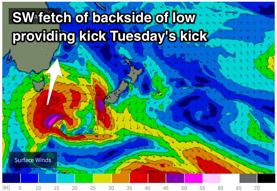
The Southern Ocean is likely to keep on giving into next week, with only a slight dip in sizes into Monday morning. South facing beaches should see options in the 3ft range early, with strong southwesterly fetches associated with a low exiting Bass Strait looking provide a kick to the 3-4ft range by the afternoon.
 The early session is looking fun under a westerly airflow, although options will likely become limited as winds tend southerly and eventually south/southeasterly.
A front and low is due to move into the swell window later on Sunday, steering a broad south/southwesterly fetch in a captured motion, with core winds upwards of 50kts. As a result, Tuesday looks to build from the 3-5ft range to a solid 4-6ft across south facing beaches by the afternoon, with the Hunter picking up more size once again.
Early southwesterly breezes should lead to workable options, although exposed south facing beaches with the most size have a fair chance of being bumpy. As the day wears on, conditions look to deteriorate as winds tend onshore.
This energy will likely fade from the 4-5ft range throughout Wednesday, with decent options early under a southwesterly breeze. Locations south of Sydney may see fairly gusty breezes, easing and tending southeasterly later.
An elongated fetch over the deep Southern Ocean then looks to become the focus of attention, providing a fresh but inconsistent swell later in the week.
Models also suggest this fetch to move in a captured motion, slingshotting from well below SA up towards the NSW swell window. Inconsistent sets are due to fill in on Thursday, building to the 3-5ft range by the afternoon.
The morning session has the potential to see a light southwesterly airflow, although easily susceptible to a southeasterly breeze as the morning wears on.


Comments
The long period south swell still on track for sunday morning?
Came in nicely across Victoria, Tasmania and South Oz today so should be lining up for Sunday still. This evenings buoy data will offer a better idea though.. I'll take a look then.
How's it looking and any indication of what would be the size of sets on exposed places?
Check Ben's notes above James, explains it?.. EH.....,,
1-20ft in exposed breaks, options above the reading line?
James, read between the lines, or just go and on a journey yourself to find, the 1-20ft.
End of story and that's it JAMES;)
Ha pretty darn small this morning let's hope some swell fills in throughout the day
I think the forecast models, got it right for today. Adding a couple of feet was a bit optimistic
Plenty of nice lines pushing through but yeah it's definitely a little undersized. Seen a couple of sets almost nudge the 2-3ft mark but it's typically inconsistent.
Bondi

Manly

Definitely swell on the east coast tday- some spots were pumping-
Newcastle?
Wow.. pumping. I think I know where it is but the lack of tankers on the horizon is making me second guess myself. Broadly speaking, which coast are you on lom?
Haha was about to say the same thing.. Where are the tankers? Ha
Always the way, make an adjustment for the undercalling model, and everything is looking sweet (ie Vicco and Tas) and then it bloody doesn't show up :p
I went to a swell magnet north of Sydney and the swell from the east that was there Saturday was more dominant, with inconsistent 2ft sets. The odd sneaker bomb, but not what I was expecting. Bugger.
East coast NSW- thats all i'm saying ;)
Ha! Of course.. all good. Stoked you scored though, looks pretty solid (and bang on Guy's expectations too.. just a shame the same size range didn't quite make it as far north).