Interesting SE swells on the way

Sydney, Hunter and Illawarra Surf Forecast by Ben Matson (issued Monday 25th May)
Best Days: Tues: inconsistent but solid S/SE groundswell with generally favourable winds (good early), easing Wed with light winds. Thurs: small and clean. Fri: possible SE groundswell with offshore winds. Sat: small SE and S'ly swell with good winds.
Recap: The weekend punched well above its weight, coming in a couple of feet bigger than expected on Saturday, and clean conditions persisting across more areas than anticipated, for much longer than forecast. Even Sunday was a foot above expectations, and conditions remained perfectly clean all day with light offshore winds. Today we’ve seen wave heights temporarily dip this morning (again, with perfect conditions) but a new S/SE groundswell - due to peak on Tuesday - has showed up much earlier than expected, and solid 4ft sets have been observed across open Sydney beaches since about lunchtime.
This week (May 26 - 29)
The weather system responsible for tomorrow's anticipated S/SE swell performed quite impressively, recording S’ly winds of 50-60kts immediately south of New Zealand over the weekend. Although this is not very well aligned within our swell window, we will still see a considerable pulse of sideband energy from it throughout Tuesday.
South facing beaches will see the biggest waves - somewhere in the 3-5ft range at times - and conditions should be clean with early W/SW winds tending SW during the day then S’ly late afternoon. Expect smaller surf at locations not open to the south, however bigger waves (5-6ft sets) are possible at offshore bombies and some swell magnets due to the large swell periods (likely to be in the 17-18 second range).
Tuesday’s swell will then ease slowly through Wednesday with light variable winds maintaining excellent conditions just about everywhere. A further small drop is likely into Thursday, and conditions will remain excellent as a series of fronts approaching from the west steer local winds around to the NW. Most open (south facing) beaches should still 2-3ft sets though, with smaller waves elsewhere.
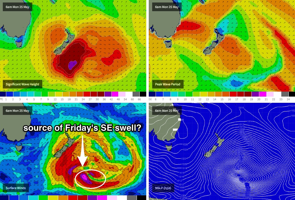
Friday has some really interesting possibilities, that may well deliver some great waves from a very rare part of our swell window. The intense low pressure system now south-east of New Zealand that’s responsible for Tuesday’s S/SE swell (in Southern NSW) is expected to merge with another deep low pressure centre overnight tonight, just to the east (see chart below). Storm force E/SE tending SE then S’ly winds feeding into this system are expected to briefly show strength in our remote SE swell window - right on the other side of New Zealand - and I think we’ll see a pulse of long range SE groundswell arrive on Friday morning from this source.
It’s hard to be too confident on what we’ll see at the coast, because these kinds of patterns don't happen very often and the fetch will be positioned right on the periphery of the swell window (so much so, that it’ll really favour the South Coast the best, with surf size easing steadily north of about Seal Rocks due to the shadowing effects of New Zealand’s South Island).
However I think we’ll see a decent flush of quality surf in the 3-4ft+ range across the Sydney, Hunter and Illawarra coasts, with very long waits between sets. Winds are expected to remain NW so if all comes to play there’ll be some really nice waves to finish the week. Our remaining swell windows will be inactive through the second half of the week so this is our only source of energy for Friday.
This weekend (May 30 - Jun 1)
Nothing amazing is expected for the weekend at this stage. The Southern Ocean storm track looks like it’ll be mainly aimed away from our swell window; we have a few small pulses of south swell on the cards but no real size is expected.
Friday’s SE groundswell should still be with us early Saturday morning but it’ll be trending quickly downwards during the day - I don't think there’ll be much more than a very inconsistent 2-3ft at exposed beaches early on, with smaller waves through the afternoon.
A small front exiting eastern Bass Strait on Friday afternoon may also supply a small south swell concurrently for Saturday but it won’t be any bigger than the pre-existing SE swell. Conditions should be clean with light offshore winds.
Otherwise, an even smaller but long period S’ly swell is due sometime Sunday, from the parent low (to Friday’s front existing Eastern Bas Strait), located well south of Tasmania on Thursday. South facing beaches may pick up a foot or two of inconsistent surf but at this stage that’s about it. Hopefully the models will upgrade the weekend outlook into the coming days - but for now Saturday morning should have some small clean options.
Next week (June 2 onwards)
A deepening trough north of New Zealand from Friday onwards looks set to generate a small E/NE swell for us early next week. No major size is expected but we should see a few small waves at open beaches in the 2ft+ range from Monday afternoon through until about Wednesday or thereabouts.
Elsewhere, with the Long Wave Trough expected to remain slow moving to the west of Tasmania for most of the forecast period, it may not be until the middle of next week where it clears into the Tasman Sea’s swell window and we can anticipate a stronger renewal of southerly swell for the second half of the week. Until then, our primary south swell window looks like it’ll remain a little inactive. More on this in Wednesday’s update.