Wide range of building swells all week, holding over the weekend
Sydney, Hunter and Illawarra Surf Forecast by Ben Matson (issued Monday 9th February)
Best Days: Tues/Wed: small S/SE tending SE then E'ly swell with light winds early. Thurs thru' Sun: small E/NE swell building, peaking late Fri, holding Sat, easing slowly Sun. Next week: chance for a large E/NE groundswell
Recap: Super fun S/SE swell on Saturday with early light winds. Much smaller size through Sunday with similar winds. Small SE groundswell early this morning with fresh S/SE winds that have whipped up an additional windswell for the afternoon.
This week (Feb 10 - 13)
Should be some fun lil’ beachies on offer on Tuesday, as today’s southerly winds tend light and variable early morning before freshening from the north-east during the day.
The small SE groundswell in the water today will be gone, but we’ll see a mix of short range S/SE tending SE swell originating from a moderate ridge building across the central/southern Tasman Sea. Wave heights should manage 2ft+ at south facing beaches but it’ll be smaller at locations not open to the south.
On Wednesday, we’ll see a mix of short range SE tending E’ly swell as the ridge broadens across the Northern Tasman, linking up with a more established trade flow that’s developing north of New Zealand, and is expected to provide us with a steady source of swells for the long term.
I don’t think we’ll see much more size than Tuesday (peaky 2ft+ sets at exposed beaches) but the slight directional shift should allow for a more uniform size distribution across the coast. Freshening north-east winds will however create problems during Wednesday. We may see a few pockets of light variable winds early morning but it probably won’t last long. So, aim for an early paddle.
Through Thursday and (more likely) Friday, we’ll start to see a new long range E/NE swell filter into the coast, being generated by the most active region of the established trades, just N/NE of New Zealand. Unfortunately, model guidance has rotated this fetch marginally clockwise over the weekend, and is now aiming the bulk energy up into the Queensland coast. However, the considerable width and length of the fetch, plus its stationary nature should ensure a healthy swell is generated that should filter nicely into southern New South Wales.
As such, I’m expecting good 2-3ft+ surf from the E/NE building through Thursday, with Friday expected to continue a slow building trend all day, peaking in the 3-4ft+ range towards the evening at reliable swell magnets open to the NE (much smaller at south facing beaches). Moderate to fresh north-east winds are expected both days but the mornings (especially Thursday) should see periods of light and variable winds.
This weekend (Feb 14 - 15)
Looking pretty good for the weekend. Friday’s late pulse of E/NE swell should level out into Saturday with consistent 3-4ft waves at NE facing beaches (smaller at south facing beaches) but current guidance suggests fresh NE winds for most of the day excluding a brief period of light variable winds early morning. On Sunday we’ll probably see wave heights tail off a little, but still remain reasonably consistent out of the E/NE (say, 2-3ft+?) with similar winds. Early mornings will certainly offer the best waves.
Next week (Feb 16 onwards)
Although the established trade flow north of New Zealand is now expected to focus its intial energy north of Sydney, the good news is that we seem to be in the early stages of a developing blocking pattern, of considerable proportions.
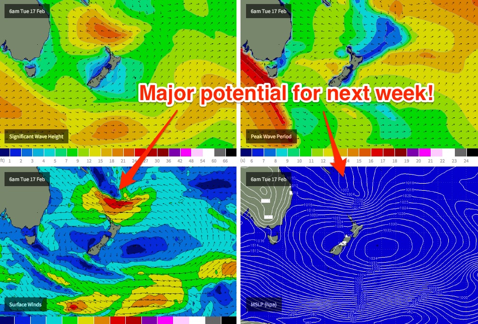
What this means is that this trade flow will remain entrenched across the Northern Tasman Sea for quite some time. In fact, the latest computer models are showing a broad tropical depression moving south from a position east of New Caledonia during the weekend, ridging against the large stationary high over New Zealand longitudes early next week (see chart below), and generating a very strong groundswell for the early to middle part of next week, and likely to hold through until the end of the week.
While it’s still too early to pin down size estimates, this is certainly shaping up as an extended period of quality groundswell from the eastern quadrant, with a very good chance of some sizeable waves mid-next week thrown into the mix. More on this in Wednesday’s update.


Comments
O dear another POTENTIAL swell event from the north again next week. Fingers X
These forecasts keep the work week very exciting! Usually very accurate - keep up the great work!
Finally some waves coming through...
vanio where you been looking? you could count the flat days over the last 6-8 weeks on one hand?
Yeah, I agree, I've had consistently good waves all summer. I can't believe how many south swells we've had it's been all time.
Today's surf is punching higher than expected - looks a good consistent 3-4ft at Bondi this afternoon. Very surprising since the responsible ridge wasn't particularly strong yesterday - I suppose the larger-than-expected size could be the result of a more stationary fetch position (which is not particularly common from this part of our swell window). Looks bloody fun across the open beaches either way with sea breezes currently under 10kts.
yup, at turn of the tide this morning there was consistent over head height faces for the hour i was in the water. i didn't see this arve. fingers crossed this east swell materialises.