Average outlook until later in the week

Southern Tasmanian forecast by Craig Brokensha (issued Friday March 7th)
Best Days: Keen surfers tomorrow morning, Friday morning
Features of the Forecast (tl;dr)
- Easing SW swell tomorrow with N/NW tending S/SE winds
- Tiny Sun with N/NE tending E/SE winds
- Small, inconsistent W/SW groundswell building Mon PM, peaking Tue AM, easing
- N/NW tending strong S/SE winds Mon, strengthening E/NE tending NE on Tue
- Tiny Wed with N/NE winds
- Small, inconsistent W/SW groundswell Fri with N/NE tending E/NE winds
Recap
The surf was onshore and tiny yesterday, while some small new swell due today only came in at 1-1.5ft this morning with some slightly better sets to 1-2ft showing this afternoon.
This weekend and next week (Mar 8 - 14)
Any swell seen today is due to start easing through tomorrow with 1ft to occasionally 2ft sets still likely to be in the mix across Clifton with a N/NW offshore ahead of sea breezes.
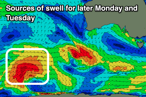
Sunday looks tiny, while into Monday afternoon/Tuesday, a new, inconsistent, long-range W/SW groundswell is due to build. A trough will unfortunately bring strong S-S/SE winds into Monday afternoon when it starts building, shifting E/NE-NE and with strength on Tuesday when it eases.
The source was a distant and strong polar low moving across the Heard Island region this week, with slow 1-2ft sets expected at the peak across Clifton though with those average winds.
Wednesday should be cleaner under a N/NE flow but with tiny leftovers.
From later in the week onwards we’ve got some better swell producers on the cards, that being strong polar lows forming south-west of Western Australia. The first swell for Friday looks only to be an inconsistent 2ft, with greater potential later next weekend. More on this Monday, have a great weekend!