Slightly better wind outlook for Sunday morning

Southern Tasmanian forecast by Craig Brokensha (issued Friday February 28th)
Best Days: Tomorrow morning, Sunday morning, Monday morning, Tuesday morning
Features of the Forecast (tl;dr)
- Small W/SW swell for later today, easing tomorrow AM with N/NW tending W/NW winds
- Moderate sized W/SW swell for Sun and Mon AM
- Moderate W/SW tending fresh S/SW winds tomorrow AM (likely W/NW in the AM)
- Light W/NW tending S/SE winds Mon
- Fading swell Tue with moderate N tending stronger NE winds
Recap
The surf bottomed out yesterday while today we’ve seen a minimal lift in swell to 1-1.5ft as the first pulse of W/SW energy fills in.
A better increase is due later but winds are due to shift more SW.
This weekend and next week (Feb 29 - Mar 7)
The current small to tiny W/SW swell should pulse a little later today and early tomorrow before easing, owing to another acute pulse of W’ly swell filling in.
This will be the second from a healthy but northerly positioned frontal progression moving under the country this week. 1-2ft sets may be seen across Clifton, easing into the afternoon under N/NW tending NW winds.
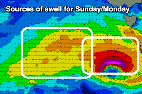
Come Sunday, a stronger increase in W/SW swell is due, generated by the third and strongest frontal system in the current progression, though the strength of this system has been downgraded a little.
A tight fetch of W’ly gales south-west of us tomorrow should generate a kick to 2-3ft on Sunday but with W/SW tending S/SW winds. There is a good chance of W/NW breezes through the morning though, while Monday looks cleaner with a light W/NW breeze and easing 2-3ft sets.
The rest of the week looks small to tiny ahead of some possible new swell later in the week. More on this Monday, have a great weekend!