Building swells for the coming period with generally OK winds

Southern Tasmanian Australian forecast by Craig Brokensha (issued Wednesday February 26th)
Best Days: Friday morning, Saturday morning, Monday morning
Features of the Forecast (tl;dr)
- Fading swell tomorrow with N tending stronger E/NE winds
- Small SW swell Fri AM, with a stronger pulse later, easing Sat
- N/NW tending SW winds Fri with N/NW tending W/NW winds Sat
- Moderate sized SW swell Sun with SW winds, freshening
- Easing swell Mon with N/NW tending SE winds
Recap
The surf was tiny yesterday while a small lift in mid-period SW swell was seen today to 1-2ft with early light winds, then deteriorating.
This week and weekend (Feb 27 - Mar 2)
There might be a tiny wave left in the mix tomorrow with sets to 1-1.5ft under early offshore winds, but a shift in winds to the E/NE through the afternoon, strengthening.
From Friday through the weekend we should see building levels of W/SW swell, thanks to a series of back to back frontal systems moving in, under Western Australia from yesterday through Friday.
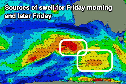
The first system wasn’t ideal at all but the remnants have generated a good fetch of W’ly winds at southern latitudes, producing an inconsistent 1-2ft wave for Friday morning.
Behind this, a more northerly positioned and stronger front should produce a slightly stronger pulse of energy for Friday afternoon more to 2ft before easing back from 1-2ft on Saturday.

We’ve then got a third increase in size due on Sunday, produced by a third, stronger low racing in from the west, generating a fetch of severe-gale W’ly winds through our western swell window, slowing in its movement through our swell window on Saturday.
This looks the best swell producer with an easy 3ft of swell likely Sunday morning, but an early SW change will create average conditions, cleaner Monday with easing 2ft+ sets.
Longer term the outlook is slower next week, but more on this Friday.