Fun few days of surf

Southern Tasmanian forecast by Craig Brokensha (issued Wednesday February 19th)
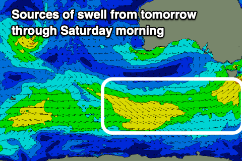
Best Days: Tomorrow morning, Friday, Saturday morning
Features of the Forecast (tl;dr)
- Small-moderate sized mid-period SW-S/SW swell tomorrow and Friday, easing Saturday
- W/NW tending W/SW winds from later AM tomorrow
- N/NW-NW tending variable winds Fri ahead of late sea breezes
- N tending strong E/NE winds Sat
- Strong N/NE-NE winds Sun with tiny surf ahead of a late SW change
- Moderate sized SW swell likely next Thu with S/SE winds
Recap
Yesterday was small and clean with easing levels of S/SE swell ahead of an onshore change, while today we’ve got a mix of new swells to 2ft+ under offshore winds.
This week and next week (Feb 20 - 28)
Our current mix of swells are due to ease into tomorrow but we should see a polar front pushing up and into us this afternoon generating some new mid-period SW swell for tomorrow morning to 2ft+.
Trailing fetches of strong W’ly winds should maintain similar sized surf into Friday and Saturday morning, easing through the day.
Local winds should veer back to the W/NW for a period tomorrow morning before shifting back to the W/SW later morning, with Friday seeing light N/NW winds ahead of relatively weak sea breezes.
Saturday morning should see light N’ly winds in the morning before strong E/NE sea breezes kick in, strong N/NE-NE all day Sunday with tiny amounts of swell and a late SW change.
Moving into next week, and a strong mid-latitude forming north of our swell window on Friday won’t generate any decent swell for us early next week, with the remnants of it possibly producing a tiny 1ft+ wave into Monday afternoon/Tuesday morning.
Otherwise a late forming frontal system to our south-west Tuesday/Wednesday should produce moderate levels of mid-period SW swell for Thursday to 2-3ft or so, but local winds at this early stage look dicey and light to moderate from the S/SE. More on this Friday.