Tiny swells for the period
Southern Tasmanian Forecast by Craig Brokensha (issued Monday December 2nd)
Best Days: Monday morning
Features of the Forecast (tl;dr)
- Tiny tomorrow
- Small to tiny W/SW swell building Wed with W/NW tending SE winds
- Fading swell Thu with morning offshore winds
- Tiny W/SW swell building Sat PM with NW tending E/NE then strong S winds
- Easing swell Sun with strong W/SW winds
- Small W/SW swell building Sun PM, easing Mon with N/NW tending SE winds
Recap
Early Saturday morning was best with 2ft of easing swell and mostly clean conditions before easterly winds sprung up and freshened through the day.
Yesterday was poor with onshore winds and a tiny swell.
Into this morning a little increase in swell was seen with clean conditions before winds freshened from the west.
This week and weekend (Dec 3 - 8)
As touched on last Friday, we’ve got a mostly tiny forecast ahead thanks to incoming swells arriving from the west.
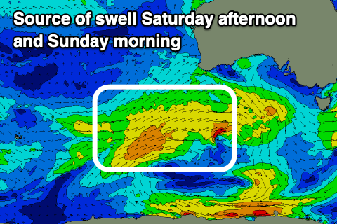
This is due to the swell generating storms sitting north in our swell window, to the South West of Western Australia.

The best looking swell of the bunch is due Wednesday, peaking into the afternoon but it only looks to reach 1-1.5ft or so along with W/NW tending SE winds.
The swell will fade into Thursday and Friday but come the weekend, a slightly more southerly positioned but weaker fetch of W/SW winds should generate some new W’ly swell that looks to kick to 1-1.5ft Saturday afternoon before easing from a similar size on Sunday.
Unfortunately winds on Saturday afternoon look onshore, while Sunday also looks dicey with strong W/SW winds owing to a strong front moving through.
This front should generate some new mid-period W/SW swell for later Sunday and more so Monday to 2ft+ along with an offshore N/NW breeze. We’ll confirm this on Wednesday though.

