Good tomorrow, dicey thereafter
Southern Tasmanian Forecast by Craig Brokensha (issued Friday November 22nd)
Best Days: Tomorrow ahead of the change, Wednesday morning, Friday morning
Features of the Forecast (tl;dr)
- Mod sized S/SW swell tomorrow with N/NE winds ahead of a late S'ly change
- Easing surf Sun with lingering S winds
- Smaller Mon with variable tending S winds shortly after dawn
- Small W/SW swell building Tue with freshening S winds
- Easing swell Wed with variable tending S/SE winds
- Moderate sized, inconsistent W/SW groundswell building Fri with variable tending strong E/NE winds
Recap
Yesterday morning started around the 2ft range with clean conditions, while a new groundswell filled in through the day, providing better 2-3ft sets but with sea breezes.
This morning the swell was back to the 2ft range, smaller this afternoon and poor with sea breezes.
This week and weekend (Nov 23 - Dec 6)
Our good pulse of new S/SW swell for tomorrow is still on track with the strengthening polar low linked to it since moving east out of our swell window.
We should see a good kick back to 3ft on the sets tomorrow morning, easing through the day and then smaller on Sunday.

Light N/NE winds are due tomorrow morning, increasing a little before tending variable ahead of a late afternoon S’ly change.
The trough associated with this change looks to linger in the region, bringing moderate S-S/SE winds on Sunday as the swell eases.
Monday looks dicey as the trough lingers in the region, bringing variable winds at dawn but then shifting quickly to the S’th.
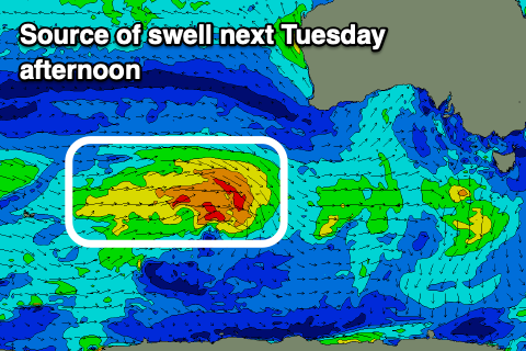
Looking at the rest of the week and a fun W/SW swell is due on Tuesday, generated by a healthy frontal system moving in, under the country on the weekend but S-S/SE winds will persist, adding bumps to the 1-2ft of swell.

More variable breezes with fading 1-2ft sets are likely Wednesday, while come Friday, a new pulse of inconsistent but strong W/SW groundswell is due.
The source will be a strong polar low forming around the Heard Island region this weekend, generating a fetch of severe-gale to storm-force W’ly winds while moving east.
The swell should build Friday and reach 2-3ft into the afternoon but conditions are a touch dicey with variable tending strong E/NE winds likely. We’ll have a closer look at this Monday. Have a great weekend!

