Tricky winds for the coming days, cleaner but easing on the weekend
Southern Tasmanian Forecast by Craig Brokensha (issued Wednesday October 23rd)
Best Days: Dawn tomorrow, Saturday morning, Wednesday morning
Features of the Forecast (tl;dr)
- Easing swell tomorrow with strong W/SW winds (W/NW at dawn)
- Small S swell Fri with strong S/SW winds
- Easing S swell Sat with N/NE tending E/NE-NE winds
- Building SW swell Mon with strong W/SW tending SW-S/SW winds
- Easing swell Tue with W/SW-SW winds
- Moderate sized SW groundswell Wed with variable tending E/NE winds
Recap
Yesterday saw a small pulse of swell to 1-2ft through the morning with clean conditions before fading as strong sea breezes kicked into the afternoon.
Today our strong pulse of SW swell was a touch delayed with early only coming in at 2ft or so, but the swell since kicked to a good 3ft with offshore winds. Winds have since gone onshore.
This week and next (Oct 24 - Nov 1)
Today’s swell is due to ease back tomorrow from the 2ft range but with strong W/SW winds, possibly W/NW at dawn.
Into Friday and Saturday some fun S’ly swell energy is due, generated on the southern flank of the low moving under us, bringing today’s swell.

This should come in around 2ft, Friday, easing back from 1-2ft on Saturday.
Unfortunately a trough will bring strong S/SW winds Friday, with Saturday being cleaner under a N/NE offshore ahead of E/NE-NE sea breezes.
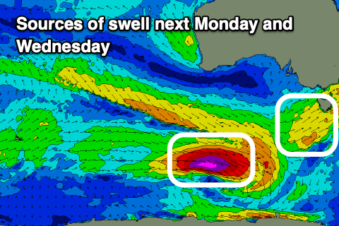
The next increase in swell is due Monday as a cold front pushes up and into us, bringing a mid-period increase in SW swell but with strong W/SW tending SW-S/SW winds.
These winds unfortunately look to linger into Tuesday as the swell eases, while a stronger polar low moving in behind the frontal system this weekend should produce a stronger SW groundswell for Wednesday.
A fetch of severe-gale to storm-force W/NW winds should produce moderate levels of SW groundswell Wednesday, coming in at 3-4ft with variable morning winds. Check back here on Friday for confirmation on the swell size and local winds.

