Mixed swells and conditions this week
Southern Tasmanian Forecast by Craig Brokensha (issued Monday October 7th)
Best Days: Wednesday morning, Friday morning, Saturday morning, Sunday morning
Features of the Forecast (tl;dr)
- Weak S/SW swell tomorrow AM, easing with strong W/SW tending SW winds
- Easing swell Wed with N/NW tending W winds
- Tiny Thu AM ahead of a late increase in W'ly swell with N tending strong W winds
- Small-mod sized W/SW swell Fri with N/NW tending strong W/SW windx
- Moderate sized S/SW swell Sat with W/NW tending W/SW-SW winds
- Easing swell Sun with N tending S winds
Recap
The East Coast provided the best waves on the weekend with near flat conditions across Clifton.
Today a tiny W/SW swell is providing 1-1.5ft waves with a morning offshore, but a deepening low is now moving across us with an onshore change due to bring some localised swell later.
This week and weekend (Oct 8 - 13)
The change moving through today is thanks to a strengthening but not overly significant low moving across us, with a fetch of strong S/SW tending SW winds due to kick up some localised swell for tomorrow morning to 2ft to occasionally 3ft. The swell will ease through the day and strong W/SW tending SW winds will create generally poor conditions.
Wednesday looks cleaner but the size will be fading from 2ft max on the sets with a N/NW tending gusty W’ly wind.

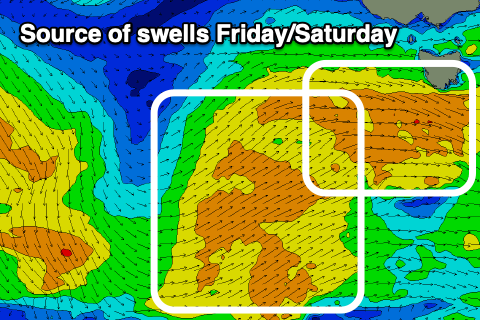
The next pulses of swell will arrive from the west from Thursday afternoon through Saturday with a strong frontal progression moving in under the country due to continue with strength under us on Thursday/Friday.
This should generate moderate levels of mid-period W/SW swell for later Thursday to 2ft or so with strong W winds, holding Friday to a similar size with N/NW tending strong W/SW winds.
On the tail of this activity we’ll see a better aligned fetch of strong SW-S/SW winds pushing up and into us Friday afternoon/evening.
Clifton should reach 3ft+ on Saturday with a morning W/NW wind, shifting W/SW-SW into the afternoon, easing Sunday from 2ft with a N’ly offshore.
Longer term, we could see a good new swell early next week but the models diverge regarding this. Check back here on Wednesday/Friday for more details.

