Strong swell pulses with tricky winds
Southern Tasmanian Forecast by Craig Brokensha (issued Friday September 20th)
Best Days: This afternoon, tomorrow, Sunday, Monday morning, Tuesday
Features of the Forecast (tl;dr)
- Moderate sized, easing surf tomorrow with strong W/NW-W winds, easing and tending W/NW-NW later
- Temp smaller Sun AM with building mid-period W/SW swell into the PM
- Light N/NW tending stronger W/NW winds Sun
- Moderate + sized W/SW groundswell filling in Mon with strong NW tending W/NW and then W/SW winds
- Reinforcing moderate sized W/SW groundswell and mid-period SW swell Tue AM, easing
- Moderate N/NW-N tending strong N/NE winds Tue
- Smaller Wed with strong W/SW tending SW winds
Recap
The swell dropped back to the 2ft range yesterday morning, while today we’ve seen a solid increase in W/SW groundswell. The morning was 3ft or so but sets are now a strong 4-5ft but straight.

Strong but straight lines this afternoon
This weekend and week (Sep 21 - 27)
Today’s large W/SW groundswell will peak this afternoon and back off into tomorrow, slowed by some smaller, reinforcing W/SW energy.
Clifton should still be 4ft on the sets but generally 3-4ft, easing through the day and with tricky, strong W/NW-W winds, easing and tending more W/NW-NW later.
Come Sunday the surf looks to be temporarily smaller and back to the 2ft+ range with light N/NW winds, strengthening from the W/NW into the afternoon.
This increase in wind will be along with a strong, approaching polar front, with building levels of mid-period W/SW swell likely later in the day to 3ft.

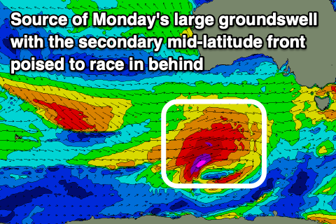
On Monday, the groundswell component from the polar low is due to fill in, with a fetch of severe-gale to storm-force W/SW winds due to generate a moderate sized peak in size to 4ft through the day across Clifton.
A secondary significant but very north positioned mid-latitude storm is then due to generate an additional fetch of severe-gale to storm-force W-W/NW winds through our western swell window Sunday, passing across us Monday.
This looks to generate a reinforcing but slower W/SW groundswell Tuesday morning to 3-4ft, with some mid-period SW swell in the mix, easing through the day.
Local winds thanks to this secondary front will be strong from the NW tending W/NW and W/SW on Monday, with Tuesday seeing excellent N/NW tending stronger N/NE winds.
Wednesday will be smaller and back to 2ft or so with W/NW tending strong W/SW winds as another front clips us, with a high moving in behind bringing strong W/SW tending SW winds.
More on this Monday, have a great weekend!

