Larger swells inbound
Southern Tasmanian Forecast by Craig Brokensha (issued Wednesday September 18th)
Best Days: Every day this period
Features of the Forecast (tl;dr)
- Moderate sized, easing W/SW swell tomorrow AM, with a PM increase in close-range energy
- Strengthening N/NW tending NW and then W/NW winds tomorrow
- Large W/SW groundswell Fri with gusty N/NW-NW winds
- Easing swell Sat with strong W/NW winds, tending NW later
- Smaller Sun with W/NW-W winds
- Moderate sized W/SW groundswell building Mon, peaking during the day with strong N/NW tending NW and then W/NW winds
- Reinforcing W/SW groundswell Tue with NW tending SE winds
Recap
Plenty of swell across Clifton yesterday and today thanks to a mix of SW groundswell and close-range energy today. Conditions have been clean but mostly straight. A bit more size is due this afternoon as it peaks and winds shift W/SW.
This week and weekend (Sep 19 - 22)
Today’s swell is due to ease back into tomorrow with 3ft surf again due across Clifton in the morning under a strengthening N/NW tending NW and then W/NW breeze.
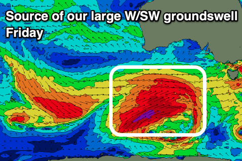
Now, into the afternoon, building levels of mid-period W/SW swell are due ahead of a larger, more significant W/SW groundswell into Friday.

The source of both these swells is a strengthening polar low that’s currently south of Western Australia, with it due to produce a great fetch of severe-gale W/SW winds while projecting slowly towards us over the coming days.
It’ll come in west in direction but size wise looks solid with 4-5ft+ sets due across Clifton along with gusty N/NW-NW winds that will hold all day.
The swell is due to then ease Saturday from the 4ft range and with a shift to strong W/NW winds in the morning, tending NW later and then W/NW-W on Sunday with a bit less size.
Moving into next week and we’ve got out secondary large swell producers on the cards, with another strong polar low due to develop south of Western Australia Friday night, projecting a tighter fetch of gale to severe-gale W/SW-SW winds towards us with embedded storm force winds.
This will generate a large W/SW groundswell for Monday that should build to 3-4ft across Clifton during the day, while a secondary stronger low rushing in quickly behind the first will generate a severe-gale to storm-force fetch of W’ly winds through the weekend.

This should produce a stronger but more westerly aimed groundswell for Tuesday morning to 4ft.
Winds on Monday look strong from the N/NW, tending NW and then W/NW through the day, with NW winds Tuesday morning ahead of a SE sea breezes.
Into the middle to end of the week, a trough looks to bring a S’ly change Wednesday afternoon, strong into Thursday along with some poor windswell. More on this Friday.

