Fun period with workable winds
Southern Tasmania Surf Forecast by Craig Brokensha (issued Friday December 22nd)
Best Days: Tomorrow morning, Sunday morning, Monday morning, Wednesday
Features of the Forecast (tl;dr)
- Peak in small SW swell tomorrow with N/NW winds ahead of S/SE sea breezes, easing Sun with variable offshore tending S/SE winds
- Small-mod sized W/SW swell building Mon (possibly undersized early), easing Tue
- Moderate NE tending strong E/NE winds Mon and Tue
- Easing swell Tue with NE winds
- Good small-mod sized SW swell building Wed with NE tending variable winds, easing Thu with strengthening S/SW winds
Recap
Tiny surf the last two mornings, but some new swell should be showing this afternoon though with average winds.
This weekend and next week (Dec 23 - 29)
This afternoon’s increase in swell is due to hold tomorrow, generated by weak but healthy frontal activity along the polar shelf earlier this week.
2ft sets are due across Clifton under a N/NW offshore before gusty sea breezes kick in.
Sunday looks tiny but fun with easing 1.5ft sets and variable offshore winds ahead of sea breezes again.

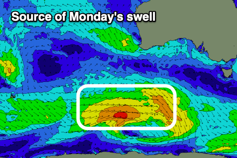
Moving into next week, our new pulse of W/SW swell for Monday is on track, though a little smaller in size. The polar low linked to it looks a touch weaker and with this, surf to 2ft+ is now expected during the day, a little undersized early. Morning NE winds are due to strengthen from the E/NE during the day limiting options, with a drop in swell Tuesday as NE tending E/NE winds persist.
As touched on last update, additional pulses of mid-period SW swell are due into Wednesday/Thursday, generated by a healthy frontal progression on the weekend and early next week.
Pre-frontal W/NW winds will be followed by slightly stronger W’ly gales and this should generate a good kick in size Wednesday afternoon to 2ft to possibly 3ft, easing from 2ft+ on Thursday morning.
Winds might go in our favour on Wednesday with a NE tending variable breeze likely as a surface trough to our east drops south, with poor, strengthening S/SW winds into Thursday. We’ll have a closer look at this on Monday and confirm it.
Longer term there’s plenty more surf on the way, have a great weekend!

