Small swell pulses for the period
Southern Tasmanian Surf Forecast by Craig Brokensha (issued Friday September 1st)
Best Days: Tomorrow morning, Sunday morning, Tuesday, Wednesday
Features of the Forecast (tl;dr)
- Easing W/SW swell tomorrow with light to moderate N tending SE winds
- Small bump of SW swell for Sun AM, easing with N-N/NE tending stronger NE winds
- Tiny Mon
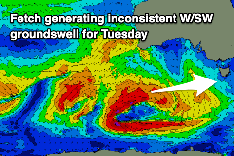
- Small, inconsistent W/SW groundswell building Tue with N/NW tending W/SW winds
- Easing swell Wed with N winds
Recap
Small to tiny but clean surf yesterday morning ahead of an onshore change, while today there's more swell in the water to 2ft+ but with average conditions.
This weekend and next week (Sep 2 - 8)
Today's swell is due to clean up and ease through the weekend, with inconsistent but fun 2ft waves tomorrow. A light to moderate offshore wind will give into afternoon sea breezes.
A small reinforcing pulse of SW swell energy is due Sunday morning, generated by a small polar low generating a burst of W/NW gales in our swell window last night.
This should maintain 2ft sets on Sunday morning, then easing along with N-N/NE tending stronger NE winds.
As touched on in Wednesday's notes, the outlook for next week is tricky with W'ly swell energy to impact the west coast but struggle to get into the South Arm.

A flurry of strong frontal activity pushing up and under the country will sit mostly too far north of us to generate an meaningful swell.
The strongest and initial low is due to drop south into our far swell window tomorrow while still generating a fetch of W/SW gales. This should produce a small pulse of W/SW groundswell for Tuesday, building to 2ft into the afternoon and then easing Wednesday from 1-2ft.
Winds look favourable and offshore from the N/NW on Tuesday morning, though shifting W/SW for the peak of the swell, then N'ly al day Wednesday.
Longer term the outlook is a little up in the air right now so check back here on Monday for the latest update. Have a great weekend!

