Fading swell this week, picking up again on the weekend
Southern Tasmanian Surf Forecast by Craig Brokensha (issued Monday August 7th)
Best Days: Today, tomorrow morning for bigger boards, Sunday, Monday
Features of the Forecast (tl;dr)
- Easing SW swell tomorrow with NW tending light SE winds
- Tiny Wed through Fri
- Moderate sized mid-period W/SW swell building Sat with N/NW tending W/SW winds, peaking Sun with variable winds
- Easing swell Mon with N tending NE winds
Recap
Bumpy, average conditions Saturday with a mix of swells, easing yesterday morning with cleaner conditions. Later in the day a new, long-period SW groundswell started to show and this has peaked this morning to a strong but straight 3ft. This afternoon looks better for a surf with the tide.

Solid but straight this morning, better now
This week and next (Aug 8 - 13)
Today's inconsistent groundswell is due to ease back through tomorrow but we should still see 1-2ft sets in the morning, fading through the day and then tiny on Wednesday through Friday.
Conditions looks generally clean with offshore winds each morning, while a trough is due to move through Thursday afternoon bringing a strong S/SW change late.
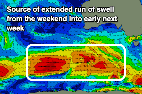
Looking at the weekend, and a healthy Southern Ocean frontal progression will start to develop later week to the east of the Heard Island region, pushing east while strengthening through our western swell window.

Back to back fetches of strong to gale-force W/SW winds should produce a moderate sized pulse of mid-period W/SW swell that will build Saturday and peak Sunday to the 3ft range on the sets, though have some longevity into early next week.
The only issue are the local winds with a trough linked to the swell generating fronts expected to move through Saturday evening but it doesn't look to do too much damage.
N/NW winds will shift W/SW into Saturday afternoon with Sunday seeing variable winds in the wake of the evening change. Monday looks to see easing 2-3ft sets with N tending NE winds.
Longer term continued frontal activity looks to generate some new swell for later week but more on this Wednesday.


Comments
Craig, my second winter in tas and my first non-Niña. Noticing a lot more WSW tracks compared with my expectation that the SWs would kick up. That's based on Vic experience though... should I expect this to continue based on latitude? Or is it an anomaly for the mo?
With Niña, the southward movement of the sub-tropical high means the storm track is also pushed further south, closer to the shelf so more SW-S/SW swells.
Otherwise with normal/Niño conditions and a lifted and more active Southern Ocean storm track, you can expect more W/SW swells for Tassie.
Ah right bummer my assumptions were off!... so it sounds like in normal/Niño Vic, even though the track is higher, the increased activity results in more swell along the surf coast. But around Hobart we are too low to make the most of that increase in activity because it's got to wrap into the bay with more W in it.
Maybe I shouldn't have been wishing Niña away after all :B
...