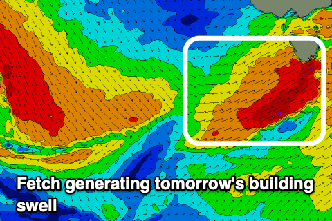
Tricky, windy swells
Southern Tasmanian Surf Forecast by Craig Brokensha (issued Monday July 31st)
Best Days: Today, tomorrow afternoon protected spots, Wednesday, later Friday, Sunday morning
Features of the Forecast (tl;dr)
- Moderate sized, building SW swell tomorrow with strong but easing W/SW winds
- Quickly fading swell Wed with N/NW tending NE winds
- Late increase in small W/SW swell Fri with N/NW winds
- Building S/SW windswell Sat with SW winds, easing Sun with NW winds
Recap
A new pulse of mid-period SW swell held in nicely to 2-3ft across Clifton on Saturday with great conditions, back to the tiny stuff on Sunday.
Today a severe cold front is pushing across the state with Maatsuyker Island picking up gusts of 96kt around 4am, that's 178km/h.
Winds were mostly NW-W/NW though resulting in slow, windy 1-2ft waves across Clifton today, under the expected 2-3ft. This is mainly thanks to the structure of the swell generating front changing a little from Friday.

Windy 2ft+ sets this afternoon
This week and next (Aug 1 - 6)
We've got another severe front moving quickly in from the west, generating a fetch of severe-gale W'ly winds which looks to be just north of our swell window today.
During tomorrow it'll draw up some better aligned, W/SW gales through our south-western swell window, generating a building SW swell through the day which looks to reach 3ft to possibly 4ft across Clifton into the afternoon.

Conditions will be dicey with windy, strong W/SW winds tomorrow morning, easing later afternoon, cleaner Wednesday morning with N/NW tending NE winds but smaller, easing 2ft to possibly 3ft sets, down to 1-2ft into the afternoon.
The swell will become tiny on Thursday/Friday, while a tricky, inconsistent W/SW groundswell may be seen into the afternoon Friday, generated by a significant but poorly aligned low that's currently south-west of Western Australia. A fetch of severe-gale to storm-force S/SW winds are aimed mostly towards Indonesia with us seeing some small side-band energy. We may see 1-2ft sets late but check back here Wednesday for confirmation.
Following this, a trough moving across us on Friday evening looks to bring a strong SW change and building S/SW windswell Saturday that might reach 2-3ft later before easing Sunday from the 2ft range.
The models diverge a little regarding this as well so have a check back here Wednesday. Longer term an inconsistent W/SW groundswell may be seen early next week, generated by a strong polar low late week but more on this Wednesday.


Comments
That wind speed at Maatsuyker Island was topped at 4pm..
Wow!
3rd reef in the main