Upgrade in next week's swell
Southern Tasmanian Surf Forecast by Craig Brokensha (issued Friday July 21st)
Best Days: Tomorrow, later Monday, Tuesday, Wednesday
Features of the Forecast (tl;dr)
- Slowly easing mid-period W/SW swell tomorrow and into Sun
- N/NW tending N winds tomorrow, fresh S/SW Sun
- Strong W/SW groundswell arriving later Mon with N/NW winds, peaking Tue AM
- Larger SW groundswell for Tue with W/NW tending variable N winds
- Easing swell Wed with N/NW tending W/NW winds
Recap
Wednesday's swell dropped right back into yesterday with tiny, windy leftovers across Clifton.
Today our mid of inconsistent W/SW swells have filled in with slow clean 1-2ft waves under light, variable winds. The swell is peaking this afternoon with easy 2ft sets for the patient.

Glassy conditions with decent sets this arvo
This weekend and next week (Jul 22 - 28)
The current mix of small W/SW swells are due to persist on the weekend, with infrequent 2ft sets padding out Clifton both Saturday (most reliable) and Sunday thanks to poorly aligned but persistent mid-latitude frontal activity through our western swell window.
Winds will be favourable all day and out of the N/NW tending N tomorrow with Sunday being poor as a trough brings a fresh S/SW change from dawn.
Monday looks clean again but tiny.

Of greater importance is a large mix of groundswells due into Tuesday.
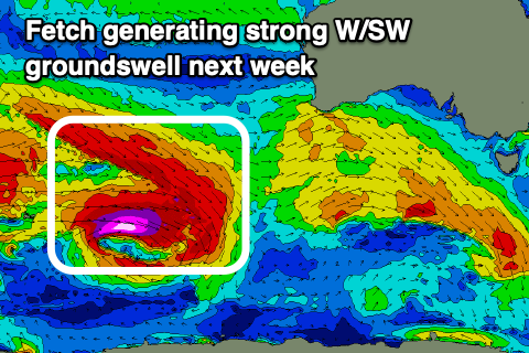
A broad, complex low has formed around the Heard Island region, with a great pre-frontal fetch of severe-gale W/NW winds sitting just above a tight fetch of core, storm-force W'ly winds while tracking slowly east-southeast.
We'll see the fetches and low breaking down while pushing closer to us, south of Western Australia, though the backside of the progression is expected to produce an additional fetch of severe-gale to possibly storm-force W'ly winds south-west of us Monday.
What this will result in is a strong, moderate to large W/SW groundswell for later Monday to 2-3ft, peaking Tuesday morning to 3-4ft.
This will be overridden by the close-range developments, with a stronger SW groundswell due to come in around the 5-6ft range across Clifton.
The fast movement of this secondary front to the east looks to bring rapidly improving winds, W/NW tending variable N into the afternoon.
This should create clean conditions across Clifton but the swell will be overpowering it.
Easing surf with N/NW tending W/NW winds are then due on Wednesday with easing 3-4ft sets.
Longer term a new W/SW groundswell may be seen next weekend, but more on this Monday. Have a great weekend!

