Fading surf tomorrow with a new pulse for Friday
Southern Tasmanian Surf Forecast by Craig Brokensha (issued Wednesday July 19th)
Best Days: Friday afternoon, Saturday morning, early Sunday, Monday, Tuesday
Features of the Forecast (tl;dr)
- Easing S/SW swell tomorrow with strong N/NE winds
- Building inconsistent mix of W/SW swells Fri, peaking in the PM, easing slowly Sat
- W/NW tending NW winds Fri, N/NW tending N winds Sat
- Inconsistent small W/SW swell Sun with W/NW tending SW winds mid-AM
- Easing surf Mon with N/NW winds
- Moderate sized W/SW groundswell Tue with N tending E/NE winds
Recap
Plenty of size left in the tank yesterday to 2-3ft across Clifton with good morning winds, while today a solid pulse of mid-period S/SW swell kicked the surf to 3-4ft but with cross-onshore winds.
Winds have eased along with the swell this afternoon with lumpier 3ft surf breaking for the keen.
This week and next (Jul 20 - 28)
The strong frontal system linked to this morning's swell is pushing quickly away to the north-east, resulting in the improvement in conditions today but this will also see the swell drop quickly overnight, dropping back from 1-2ft tomorrow morning.
Strong N/NE winds will create tricky conditions, easing into the evening.

A shallow change will move through the evening and a shift to W/NW tending NW winds is due on Friday along with a mix of new W/SW swells.
As touched on in Monday's notes, the best swell producer is a fetch of strong to gale-force W/SW winds currently to the south of Western Australia and this should provide 2ft sets into the afternoon, easing from a similar size Saturday with N/NW tending N winds.
Come Sunday an inconsistent mid-period W/SW swell is due, generated by pre-frontal fetch of strong to gale-force W/NW winds moving in from the south-east Indian Ocean. This should maintain slow 1-2ft sets but a trough is due to bring a shallow SW change mid-morning.

Easing surf is then expected Monday with clean conditions, ahead of strong, inconsistent W/SW groundswell Tuesday.
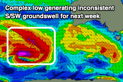
This will be generated by a broad, complex low forming around the Heard Island region over the coming days, with a great fetch of gale to severe-gale W/NW winds slipping east-southeast through our swell window.
The sustained but flurrying nature of the fetch should produce a good mix of W/SW groundswells on Tuesday, coming in at 3ft+ along with N'ly tending E/NE winds. We'll have a closer look at this swell and the local winds on Friday though.

