Plenty of chances for a surf this week
Southern Tasmanian Surf Forecast by Craig Brokensha (issued Monday July 17th)
Best Days: Today, tomorrow morning, Wednesday, Friday, Saturday morning
Features of the Forecast (tl;dr)
- Easing surf tomorrow with strong N-N/NW winds, giving into a W/SW change
- Moderate sized mid-period S/SW swell Wed AM, easing
- Pre-dawn W/SW winds Wed, tending W/NW during the morning the N/NE
- Fading swell Thu with strengthening N/NE-N winds
- Moderate sized W/SW swell Fri with N/NW winds
- Easing swell on the weekend with offshore winds
Recap
Weak, average surf on Saturday morning as we fell in between pulses, while yesterday's stronger W/SW groundswell came in on forecast with good 2-3ft sets across Clifton.
The swell was holding a similar size this morning with great conditions in semi-protected spots.
This week and weekend (Jul 18 - 23)
The current swell is due to ease this afternoon and drop further tomorrow morning but still be in the 2ft range on the sets.

Conditions will be clean under a strong N-N/NW breeze, giving way to a W/SW change around midday as cold front clips us.
This front is forecast to generate a fetch of strong S/SW-SW winds up through our southern swell window tomorrow afternoon and evening, generating a moderate sized mid-period S/SW swell for Wednesday morning.
Good sets to 3ft are due across Clifton, easing through the day. Winds look to be W/SW before dawn but improving and tending W/NW through the morning on Wednesday, so we should see improving, lumpy conditions with winds tending N/NE into the afternoon.
Thursday looks much smaller with fading 1-2ft sets under a strengthening N/NE-N breeze.
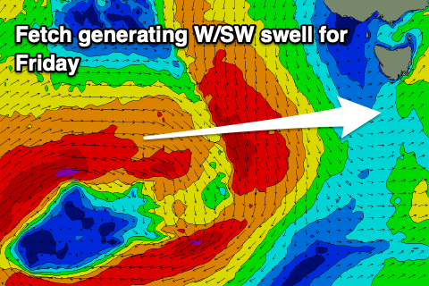
Moving into Friday, we're expected to see a fun new pulse of mid-period W/SW swell generated by a strong but weakening low dipping south-east from the southern Indian Ocean.

All the initial and strongest stages of the low look too far north of our swell window, but we should see a fetch of strong to gale-force W/SW winds generated to the south-west of Western Australia tomorrow afternoon and evening.
This will be the source of Friday's size with 2ft+ sets due across Clifton with great N/NW winds.
The swell is due to ease slowly through the weekend, becoming small to tiny ahead of the next pulse of swell which looks to be some long-range groundswell next Tuesday. We'll have a closer look at this on Wednesday though.

