Small pulses of swell for the coming days, stronger from the weekend
Southern Tasmanian Surf Forecast by Craig Brokensha (issued Monday July 10th)
Best Days: Early tomorrow and late tomorrow, Wednesday, Thursday, Saturday onwards
Features of the Forecast (tl;dr)
- Small mid-period W/SW swell tomorrow, easing Wed
- Gusty W/NW tending SW winds late AM tomorrow, back to the W/NW later
- Building S swell Wed PM, easing Thu AM
- Mod-fresh N/NW winds Wed/Thu
- Building W/SW swell later Fri but peaking Sat with NW winds
- Possible stronger W/SW swell from Sun into next week
Recap
Tiny surf on Saturday with the S/SE swell from late last week fading, while yesterday was windy with a building, closer-range W/SW swell. Today is the pick with cleaner conditions and a secondary reinforcing pulse of W/SW swell to 2ft.
This week and weekend (Jul 11 - 16)
West, west, west.
A strong negative Southern Annular Mode event is seeing the westerly storm track lifted, and focussed into Western Australia, too north of our swell window.
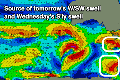
We'll see the fronts dropping east-southeast on approach to us, with a couple of tricky W/SW fetches generating small fun waves through this week.

Tomorrow should hold the 2ft range as a reinforcing pulse of W/SW swell fills in, generated by a frontal system that's currently moving in from the west and will pass under us this evening.
This swell will ease Wednesday but a small pulse of mid-period S/SW swell is due into the afternoon, generated by polar S/SW winds forming at the base of the mid-latitude front, developing this afternoon and slowing swinging more SW away from our swell window tomorrow.
This should pulse to 2ft on the sets Wednesday afternoon, fading from 2ft Thursday.
A long-period W'ly groundswell showing on the charts was generated too far north of our swell window, in the south-east Indian Ocean and isn't expected to offer much over 1ft.
Longer term the storm activity looks to dip further south and more favourably into our swell window next weekend, while coming in with a bit of strength. This looks to generate moderate sized pulses of W/SW swell from the weekend into next week but we'll have a closer look at this on Wednesday.
Coming back to the local winds over the coming days and tomorrow morning will see gusty W/NW winds, shifting SW late morning and then back to the W/NW later if we're lucky. Wednesday and Thursday look great with persistent N/NW-N winds. Come the weekend, persistent NW winds look to create favourable conditions but more on this Wednesday.

