Windy, average weekend, better next week
Southern Tasmanian Surf Forecast by Craig Brokensha (issued Friday June 30th)
Best Days: Today, possibly early Sunday but more so Monday, Tuesday, Wednesday and Thursday
Features of the Forecast (tl;dr)
- Moderate sized W/SW swell today, easing a touch tomorrow, then further Sunday
- Strong SW winds tomorrow, W-W/SW tending W/SW Sun
- N/NW tending variable E winds Mon with smaller surf
- Small, inconsistent W/SW groundswell for Tue AM, with a S/SE groundwell for the PM, holding through Thursday
- Favourable N winds most of next week
Recap
Yesterday was reported to come in smaller than expected and only to 1-1.5ft. Today's swell has come in nicely with a boost back to 2-3ft with windy buy clean conditions in protected spots.

Good swell in the water today
This week and weekend (Jun 29 – Jul 2)

Looking at the weekend ahead and the main issue are the local winds, with the final front in the progression seen this week due to push through tomorrow morning.
This will bring strong SW winds tomorrow, possibly W-W/SW Sunday morning before shifting W/SW and freshening through the day.
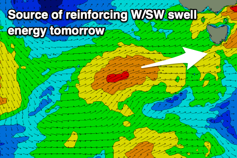
All in all not ideal and spoiling a final pulse of reinforcing mid-period W/SW swell for tomorrow afternoon.
Clifton looks to hold in the 2ft to occasionally 3ft range tomorrow, easing back from 2ft+ on Sunday.
Monday looks cleaner with N/NE tending variable E'ly breeze and smaller, easing 1-2ft sets.
Later in the day but more so Tuesday morning, a tricky pulse of W/SW groundswell is due.
This will be generated by an off-axis fetch of gale to severe-gale N/NW-NW winds developing to the south-west of Western Australia this afternoon, directed at the polar shelf.
We should see some small, inconsistent sets to 2ft spreading off this source, peaking Tuesday morning.

As the swell eases into the afternoon, some small S/SE groundswell might be seen across Clifton, coming off fetches of strong to gale-force winds to the south of New Zealand over the coming days. It'll be inconsistent but 2ft+ sets are likely later Tuesday through Thursday with a bit more size at more exposed breaks.
Winds should be favourable Tuesday morning and offshore from the N/NW, variable into the afternoon and then fresher N on Wednesday.
Longer term there's nothing too major on the cards until early the week of the 10th, but more on this Monday. Have a great weekend!

