Plenty of fun surf for the period
Southern Tasmanian Surf Forecast by Craig Brokensha (issued Wednesday June 28th)
Best Days: Tomorrow, Friday, Monday, Tuesday
Features of the Forecast (tl;dr)
- Moderate sized pulses of mid-period W/SW swell tomorrow, Friday (biggest), Saturday, easing Sunday
- Gusty W/NW tending NW winds tomorrow, fresh W/NW Friday, tending more W into the PM
- Gusty SW winds Sat, W/SW Sun
- Easing surf Mon with N/NW tending variable E/NE winds
- Small W/SW groundswell Tue with N/NW winds
Recap
Clean conditions with an easing weak swell yesterday to 1ft.
Today the swell is on the build though ragged with clean 1-1.5ft sets this morning, now bumpy and lumpy to 2ft+.

Building surf today
This week and weekend (Jun 29 – Jul 2)
The current building swell looks to be coming in stronger than expected across Victoria and our state, with 2-3ft sets due later this afternoon across Clifton that should hold into tomorrow.
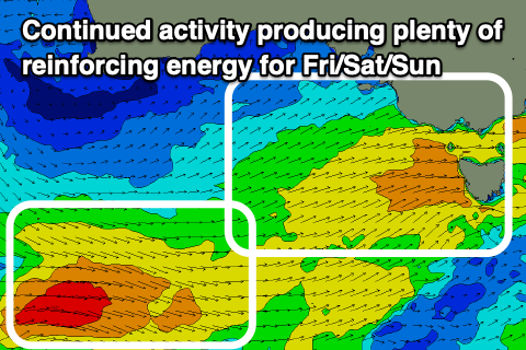
Further frontal activity moving and strengthening under us tomorrow evening and Friday should kick up a more consistent 3ft of close-range swell for Friday, dropping back to 2-3ft on Saturday, easing from a similar size Sunday morning.

Winds look decent for the coming days and gusty W/NW tending NW tomorrow, with fresh W/NW winds Friday morning, possibly shifting more W'ly into the afternoon.
Saturday is dicey as the backside of the progression moves past us, bringing gusty SW winds that may persist from the W/SW on Sunday. We'll confirm this on Friday though.
Monday looks cleaner but with swell easing from 2ft under N/NW tending variable E/NE winds.
Looking at Tuesday and we've got a funky source of W/SW groundswell, that being a fetch of gale to severe-gale NW winds developing south-west of Western Australia on Friday.
We should see some swell spreading out radially from this source, providing inconsistent 2ft sets Tuesday morning, easing into the afternoon.
Following this the storm track looks a little too far north to benefit us but we'll have a closer look at this Friday.

