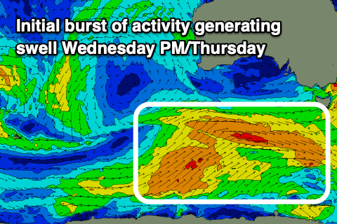
Increasing activity from mid-late week
Southern Tasmanian Surf Forecast by Craig Brokensha (issued Monday June 26th)
Best Days: Beginners tomorrow morning, Thursday, Friday protected spots, early Sunday
Features of the Forecast (tl;dr)
- Weak windswell this afternoon, easing tomorrow with N/NW winds
- Small mid-period W/SW swell building Wed PM, peaking Thu with gusty SW winds Wed, N/NW-NW Thu, tending W/NW later
- Swell holding Fri with strong W/NW-W winds
- Moderate sized (at least) S/SW swell building Sat with strong SW winds, easing Sun with W/NW tending W/SW winds
Recap
Tiny surf on Saturday with our inconsistent swell for Sunday coming in on forecast with a bit more size to 1.5ft. Conditions were great all day, with the swell similar today with clean conditions early ahead of a strong change as a cold front pushes up across us.
This week and weekend (Jun 27 – Jul 2)
The frontal system that's currently passing across us, bringing the onshore change will produce a small, short-lived windswell this afternoon, with it fading from 1ft tomorrow.

N/NW winds will create clean conditions all day for keen beginners.
Now, our mid-period swell episode due from the weekend is on track, though with the frontal systems not being overly strong in nature, we're not expecting to see any major size.
The progression is currently forming south of Western Australia, with a fetch of pre-frontal W/NW winds giving into post-frontal W/SW winds, generating a building W/SW swell Wednesday afternoon, peaking Thursday.
Clifton should offer 2ft+ sets on Thursday, with Wednesday building to 2ft though with gusty SW winds thanks to the frontal activity clipping us.
Thursday looks the pick with N/NW-NW winds most of the day, shifting W/NW later as the next front moves through.

Now, the models diverge regarding the strength of this next system but what we will see is the angle of the fronts shifting more south to north, more into our southern swell window.
This and a possible increase in strength to the gale-force range should produce some larger S/SW swell energy into Saturday but with poor, associated winds. Saturday looks average with strong SW breezes as the swell kicks, likely cleaner for a period Sunday morning but we'll review this Wednesday.
On the backside of the progression it looks like we'll see S/SE groundswell with favourable winds but check back Wednesday.

