Make the most of the building swell
Southern Tasmanian Surf Forecast by Craig Brokensha (issued Monday June 19th)
Best Days: This afternoon, tomorrow morning, Wednesday
Features of the Forecast (tl;dr)
- Moderate sized W/SW tending SW swell for tomorrow with W/NW tending W/SW-W winds
- Easing swell Wed with N/NW tending NE winds
Recap
A little lift in inconsistent W/SW groundswell on the weekend with favourable conditions across selected spots, best Saturday afternoon and evening.
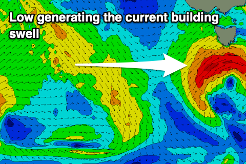
Today started tiny but a final front pushing under us is forming into a low, bringing a building W/SW swell that's now showing 2ft sets across Clifton.

Building surf this afternoon with clean conditions
This weekend and next week (Jun 20 – 25)

The current low and building swell will be worth making the most of, as the outlook into the end of the week and beyond is very slow and tiny to flat.
Currently the low is moving east, under us while generating a great fetch of gale-force W/SW winds.
The low will be slow moving, though weakening from early tomorrow morning and pushing east during the day.
As a result the localised W/SW swell will tend SW in direction tomorrow with strong sets to 3ft+ due in the morning, easing through the late afternoon and then down from 2ft on Wednesday.
Conditions will be best in protected spots tomorrow and W/NW through the morning, shifting W/SW-W into the afternoon, with Wednesday seeing excellent N/NW tending NE winds.
Following this, we're expected to see another round of mid-latitude frontal activity firing up across Western Australia but way too far north to generate any swell for us.
We may see more favourable swell generating systems fire up mid-late next week but check back here on Wednesday for more on this.

