Slow, flukey weekend, better potential early next week
Southern Tasmanian Surf Forecast by Craig Brokensha (issued Friday June 16th)
Best Days: Saturday afternoon, Sunday morning, Tuesday protected spots, Wednesday morning
Features of the Forecast (tl;dr)
- Small, inconsistent W/SW groundswell building Sat PM with strong N/NE winds, easing and tending more N/NW late
- Easing swell Sun with N/NW winds, strengthening from the N-N/NE late
- Building W/SW swell late Mon with strong NW tending W/NW winds
- Peak in SW swell Tue with strong W/NW tending W winds
- Easing swell Wed with W/NW tending W/SW winds
Recap
The surf has bottomed out the last two days, being effectively flat.
This weekend and next week (Jun 17 – 23)
We've got some small swell for the weekend but it'll be inconsistent thanks to it being very west in nature.
As talked about through the week, a strong but poorly aligned flurry of frontal activity pushing up and under Western Australia has generated some small, inconsistent groundswell that's expected to build to a slow 1-2ft tomorrow afternoon across Clifton, easing back from 1-1.5ft on Sunday.

It'll be a weekend for beginners and strong N/NE winds will create tricky conditions tomorrow, easing a touch late afternoon and tending N/NW. Sunday looks good with N/NW winds, strengthening later and tending N-N/NE.
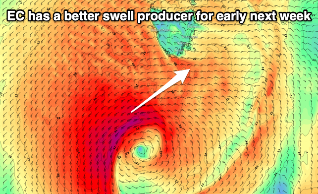
Moving into early next week, the backside of the activity pushing in from the west should produce one final burst of strong to possibly gale-force W/SW winds under us during Monday afternoon and evening.
EC has the best swell producing system, with GFS being a touch weaker so at this stage we'll set the expectations a little in between the two, with a fun 3ft of swell likely Tuesday along with strong W/NW tending W winds. Easing surf with morning W/NW winds is then due on Wednesday but we'll have a closer look at the size and timings on Monday. Have a great weekend!

