Small, slow swell for the weekend
Southern Tasmanian Surf Forecast by Craig Brokensha (issued Wednesday June 14th)
Best Days: Today beginners, Saturday afternoon, Sunday beginners, Tuesday
Features of the Forecast (tl;dr)
- Tiny, fading swell tomorrow
- Small, inconsistent W/SW groundswell building Sat PM with strong N/NE winds, easing and tending more N
- Easing swell Sun with N/NW-N winds
- Possible moderate sized W/SW swell building late Mon, easing Tue with strong but easing W/NW winds
Recap
Tiny surf yesterday with a smidge more energy today, but only for beginners.

Little runners this AM
This week and weekend (Jun 15 – 18)
Today's tiny lift of swell is expected to fade tomorrow, with Friday remaining tiny to flat ahead our small W'ly groundswell on the weekend.
Conditions will be clean with N tending N/NW winds tomorrow, stronger N tending N/NE on Friday.

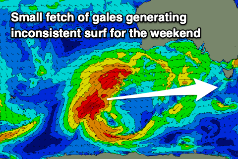
Now, looking at the weekend and the outlook is tricky thanks to the position of a strong but high-riding mid-latitude frontal progression that's currently positioned south-west of Western Australia.
Today and tomorrow will see a great fetch of gale-force W/SW winds produced north of our swell window, but at the base of this, a quick burst of gale to severe-gale W/SW winds will be just within our swell window.
The progression will then move east and produce additional fetches north of our swell window, with a brief fetch of W'ly winds just sitting in our swell window on Friday.
What this all amounts to is a tricky, inconsistent and not overly reliable W'y groundswell episode on the weekend, building Saturday and likely reaching 1-2ft across Clifton, easing from 1-1.5ft Sunday.
Conditions will be windy and tricky on Saturday with strong N/NE winds, easing and tending more N into the afternoon and then lighter, great N/NW-N winds holding all day Sunday.
Into Monday we're expected to see the final front on the backside of the progression moving in and under us, stalling and strengthening into a small low pressure system.
The models look to be converging on this scenario and with this we'll see a moderate sized increase in mid-period W/SW swell for later in the day Monday, peaking overnight and easing Tuesday from the 3ft range.
Winds look as if they'll be strong from the W/NW Tuesday morning, abating through the day but we'll have a closer look at this on Friday.

