Fun swell for the weekend
Southern Tasmanian Surf Forecast by Craig Brokensha (issued Wednesday June 7th)
Best Days: Today beginners, Saturday, Sunday, Monday morning
Features of the Forecast (tl;dr)
- Moderate sized, inconsistent W/SW groundswell building Sat, easing Sun
- Moderate sized mid-period W/SW swell for Sun AM, easing
- Strong but easing N/NW tending N winds Sat
- Mod-fresh but easing N/NW winds Sun
- Fading surf Mon with N tending fresh NE winds
Recap
The surf has faded the last two days, back from 1-1.5ft yesterday and 0.5-1ft today.

Tiny leftovers today
This week and weekend (Jun 8 – 11)
Tomorrow will be flat, as will Friday ahead of our inconsistent W/SW groundswell for the weekend.

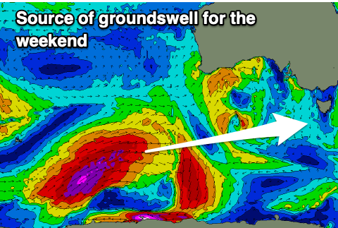
The polar low linked to this swell formed at the start of the week in our far swell window, around the Heard Island region. A great fetch of severe-gale to storm-force W-W/NW winds were produced, with it now weakening while projecting north-east towards Western Australia.
This will see the storm move north of our swell window, with us relying on the long-range energy.
The fore-runners are expected to arrive overnight Friday, with the swell building through Saturday, strongest into the afternoon. We should see strong but inconsistent sets building to 3ft+, easing from a similar size though more to 3ft on Sunday.
There'll also be some mid-period W/SW swell in the mix for late Saturday but more so Sunday morning, generated by the remnants of the low dipping back south-east into our swell window on Saturday.
Conditions for this swell look great thanks to the frontal system dipping south-east, bringing strong but easing N/NW tending N winds on Saturday, persistent from the N/NW on Sunday and moderate to fresh but easing.
Monday looks smaller with easing 1-2ft sets under a N tending NE breeze.
Longer term there's nothing major on the cards so try and make the most of the coming swells.

