Large swells inbound with clean conditions
Southern Tasmanian Surf Forecast by Craig Brokensha (issued Wednesday May 24th)
Best Days: Every day this period
Features of the Forecast (tl;dr)
- Building SW swell later Thu with gusty N/NW winds
- Moderate sized W/SW swell building Fri with NW tending W/NW winds, holding Sat with N/NW winds
- Moderate sized W/SW groundswell building Sat PM, peaking Sun ahead ahead of a stronger, larger W/SW groundswell building Sun PM
- Gusty N winds Sun AM, shifting W/NW into the PM
- Easing surf Mon with N/NW winds, smaller Tue with N/NW winds
Recap
The South Arm was still solid yesterday with a reinforcing S/SW swell to 3ft to occasionally 4ft, easing back today from 2ft.

Still some size this afternoon
This week and weekend (May 25 - 28)
We're still expecting a temporary low point in swell tomorrow morning though still 1-2ft, ahead of a small increase in mid-period swell through the afternoon. No major size is expected but we could see 2ft to possibly 3ft sets showing late.
N/NW winds will create clean conditions all day tomorrow, shifting NW on Friday morning and then W/NW into the afternoon along with a new, moderate sized WSW swell.
The source of this swell will be a broad frontal system passing across us on Thursday evening, generating a fetch of strong W/SW winds, kicking up a building mid-period W/SW swell to 2ft to nearly 3ft through the day, holding a similar size on Saturday morning.
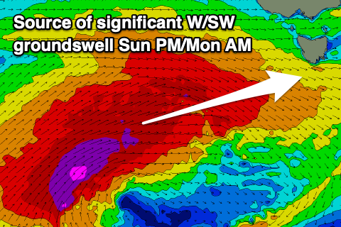
A larger increase in W/SW groundswell is due later in the day, generated by a great, pre-frontal fetch of W/NW gales forming at the head of a significant polar low to the south of the country tomorrow afternoon and evening.
This fetch alone looks to generate moderate sized W/SW groundswell that's expected to peak on Sunday morning, coming in around 4ft across Clifton, but we've got an even larger pulse of W/SW groundswell due to fill in through the afternoon.
The low proper will produce a great fetch of severe-gale SW winds initially in our south-western swell window, before projecting up through our western swell window through Friday and Saturday, on top of the active sea state generated ahead of it.
In the early stages the core wind speeds actually look to reach storm-force and this will generate a significant W/SW groundswell that is expected to pulse strongly Sunday afternoon.

Now, there is still some slight divergence in the modelling between EC and GFS, with EC having the storm being a touch smaller in scope and moving a touch slower up towards us.
What this would result in is a later arrival time Sunday afternoon, more so into the evening and with less size.
Regardless we should see building surf to 6ft later in the afternoon on Sunday with Monday easing back from 4-5ft+.
Looking at the local winds and we should see persistent N/NW breezes on Saturday, similar Sunday and N'ly through the morning but shifting W/NW into the afternoon as the larger swell starts to show.
Monday will be excellent with N/NW winds as the swell eases, clean again Tuesday under N/NW breezes.
Longer term another strong frontal progression firing up under us mid-week looks to generate moderate levels of SW groundswell for later in the week, but more on this Friday.

