Strong swell pulses continue
Southern Tasmanian Surf Forecast by Craig Brokensha (issued Monday May 22nd)
Best Days: Tuesday, Wednesday, Thursday morning, Friday, Saturday, Sunday, Monday
Features of the Forecast (tl;dr)
- Moderate sized, reinforcing S/SW swell for Tue AM, easing with NW tending variable winds
- Easing surf Wed with N tending N/NW winds
- Building SW swell later Thu with strengthening N/NW tending W/SW winds
- Moderate sized W/SW swell Fri with W/NW-NW winds, easing Sat with NW winds
- Large SW groundswell building Sun PM with N/NW tending variable winds, easing Mon with N-N/NW winds
Recap
The swell faded back way more than expected on Saturday with tiny 1ft waves reported.
Yesterday saw a choppy increase in localised swell with onshore wind sand surf to 3-4ft, cleaner and stronger today, holding 4ft or so.

Solid this afternoon
This week and weekend (May 23 - 28)
We've got plenty of swell due over the coming days and with favourable conditions with the frontal system linked to yesterday's and today's swell, seeing a trailing system generating a reinforcing S/SW swell for tomorrow.
With a fetch of strong to gale-force W/SW winds acting on top of an active sea state, surf to 3-4ft is expected to continue across Clifton with NW tending variable winds, easing Wednesday from 2-3ft with N tending N/NW winds.
A temporary low point is likely Thursday morning through ahead of a new mid-period SW swell for the afternoon.
Clifton isn't likely to get below 2ft and the afternoon should kick back to 2ft to possibly 3ft along with strengthening N/NW tending W/SW winds as a strong cold front moves across us.
This frontal system is due generate some localised W/SW swell Friday to 2-3ft as it pushes across us, and with favourable W/NW-NW winds.
Saturday looks clean but smaller as the swell eases back from 2ft.

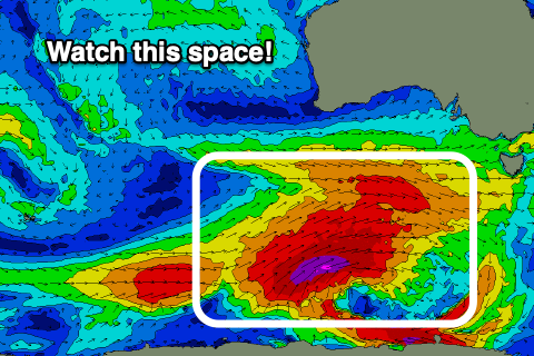
Of greater importance is a much more significant frontal progression forming under the country later week. We're expected to see a broad, elongated fetch of pre-frontal W/NW gale setting up an active sea state for post-frontal severe-gale to storm-force SW winds to project up and over on. This trailing fetch will push up and across us on the weekend, with a large, long-period SW groundswell due to follow.
EC has the system being a touch weaker than GFS but regardless we're looking at strong 5-6ft sets later Sunday, easing back from a similar size Monday and with N tending variable winds Sunday, N-N/NW all day Monday. Quite a rare combination so let's have a closer look at this and confirm on Wednesday and Friday.

