Lots of swell to come with generally favourable winds
Southern Tasmanian Surf Forecast by Craig Brokensha (issued Monday May 15th)
Best Days: Early tomorrow, Wednesday, Thursday, Friday afternoon, Saturday, Sunday afternoon
Features of the Forecast (tl;dr)
- Moderate sized SW groundswell for tomorrow, easing into the PM, with a reinforcing swell for Wed, easing Thu
- Early W/NW tending gusty SW winds mid-AM tomorrow, W/NW-NW tending variable winds on Wed
- N/NW tending NW winds Thu
- New SW swells building Fri with fresh SW winds, shifting W into the PM
- Slight drop in swell Sat with W/NW-NW winds
- Building surf Sun with gusty SW tending W winds
- Plenty of swell next week
Recap
A slow start to Saturday but a new W/SW swell provided a nice pulse into the afternoon before easing yesterday. This morning was nice and clean but still 1-1.5ft and ideal for beginners.
This week and weekend (May 16 - 21)
Later today the fore-runners of a strong new SW groundswell are due to arrive, with a peak expected tomorrow across the South Arm.
The source of this swell was a strong polar frontal progression that developed over the weekend, with a fetch of pre-frontal W/NW gales strengthening further to the severe-gale range, south-west of us last night.
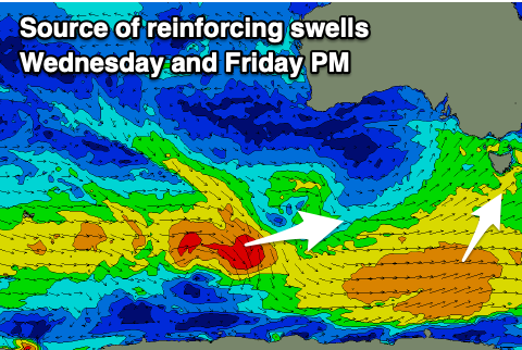
The progression was a touch faster in movement to the east than ideal, but with the strongest stages generated nicely in our south-western swell window, we should see a moderate to large groundswell peaking tomorrow to 4ft+ across Clifton, easing through the day, though slowed by some reinforcing swell energy Wednesday morning to 3-4ft.

This will be generated by a healthy trailing front, with Thursday easing from 2ft to occasionally 3ft.
Winds look dicey tomorrow as a front clips us, linked to the swell generator, with early W/NW winds due to shift gusty SW mid-morning and remain so into the afternoon.
Wednesday and Thursday will be much cleaner with W/NW-NW tending variable winds on the former, and N/NW tending NW winds on the latter.
A trough will unfortunately bring a SW change on Friday morning, shifting W'ly later morning and improving along with some fun new mid-period swell energy.
The mix of swells will be generated by trailing frontal activity over the coming days with good 3ft sets due to develop across Clifton through the day those improving winds.
Saturday looks to be a little smaller and back to 2-3ft along with clean conditions under W/NW-NW winds.
Longer term we've got stronger, larger swells on the cards for early next week but we'll have a closer look at this on Wednesday.

