Fun run of swells and clean conditions
Southern Tasmanian Surf Forecast by Craig Brokensha (issued Monday April 24th)
Best Days: Every day this period
Features of the Forecast (tl;dr)
- Moderate sized W/SW groundswell building Tue, peaking in the PM, easing Wed from the SW
- N/NW tending variable winds tomorrow, N tending fresh E/NE winds Wed
- Small, building mid-period SW swell Thu with strong N/NE winds
- Inconsistent SW swell for Fri with strong N tending NW winds
- Possible moderate sized mix of swells Sat with gusty N/NW-NW winds
- Easing surf Sun with N tending NE winds
Recap
Clean conditions to 2ft across Clifton on Saturday, while Sunday saw a strong spike in swell with surf to 3ft or so though conditions were a little lumpy. This morning the swell is smaller and back to 2ft but with clean conditions.
This week and weekend (Apr 25 - 30)
The surf will start small tomorrow, but into the mid-late morning a new pulse of W/SW groundswell is due to fill in, peaking through the afternoon.
The source was a strong but poorly structured low moving in from under Western Australia, generating a fetch of weakening gale to severe-gale W/NW winds.
The system broadened while passing under us today, with the swell due to initially arrive from the W/SW tomorrow but then ease out of the SW on Wednesday.
Building sets to 2-3ft are due through the day tomorrow easing back from 2ft sets Wednesday.

Conditions tomorrow look great all day with a N/NW tending variable breeze, with Wednesday seeing N tending E/NE winds.
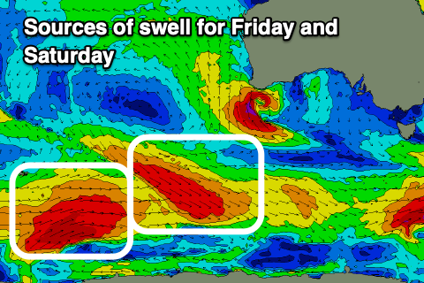
Into Thursday but more so Friday a new pulse of mid-period SW swell is due, generated by a healthy fetch of gale-force tending strong W/NW winds swinging in from the Heard Island region. A small lift to 1-2ft is likely on Thursday afternoon with Friday coming in at 2ft+.
Following this, a secondary, less consistent and similar sized swell may be seen on Saturday but this looks to be mixed with a close-range swell as a strong low develops west of us and pushes under the state Friday evening.
We may see a spike in swell to 2-3ft but we'll have to review this on Wednesday.
Coming back to local winds and Thursday will see strengthening N/NE winds ahead of a weakening mid-latitude low, N tending NW on Friday and persistent N/NW-NW winds on Saturday.
Longer term, more westerly swell energy is on the cards, but more on this Wednesday.

